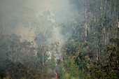
14123500 - Smoke rises from a wildfire in Bogota's eastern mountains , wildfires rose to 5 during January 24, 2024, after hot temperatures and no precipitation was caused by the Nino Phenomena.14126490 - Smoke rises from a wildfire in Bogota's eastern mountains , wildfires rose to 5 during January 24, 2024, after hot temperatures and no precipitation was caused by the Nino Phenomena.13830903 - Drought illustration, cracked earth when the water dries up from lack of precipitation, blaye, gironde, france13830904 - Drought illustration, cracked earth when the water dries up from lack of precipitation, blaye, gironde, france71065344 - View over the crater rim consisting of ash an on the turquoise blue acid lake of Ijen volcano. Ash washed out by precipitation, gases emitting, East Java, Ijen volcano, Indonesia71103379 - Very intense high precipitation supercell storm moves south in the Nebraska Sand Hills south of Valentine, July 13, 2009. Very low, long and fat inflow cloud stretches east of the storm. Winds gusted upwards of 60+ mph into this storm. Tornado warning wit71103366 - Very intense high precipitation supercell storm moves south in the Nebraska Sand Hills south of Valentine, July 13, 2009. Winds gusted upwards of 60 mph into this storm. Tornado warning with the storm mentioned baseball size hail and winds in excess of 1071103363 - High precipitation supercell storm tracks south of Hastings Nebraska June 15, 2009 as irrigation pivot waters the field ahead of the storm.71103365 - Very intense high precipitation supercell storm moves south in the Nebraska Sand Hills south of Valentine, July 13, 2009. Winds gusted upwards of 60 mph into this storm. Tornado warning with the storm mentioned baseball size hail and winds in excess of 10