Kilometer Photos – License unique travel photos ❘ lookphotos
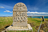
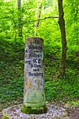
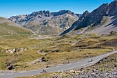
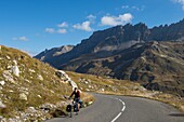
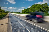
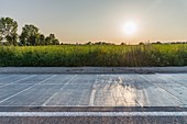
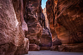
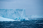
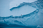
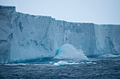
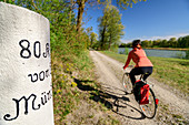
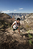
71448809 - Kilometer 518 waymarker sign on the Rhine with Hotel Schwan and church seen from river cruise ship, Oestrich-Winkel, Hesse, Germany, Europe71444529 - 1000 kilometer stone for the GR 34, Pointe de Pen-Hir, GR 34, Zöllnerweg, Sentier Côtier, Crozon peninsula, Atlantic coast, Brittany, France71382374 - Altmühl Panoramaweg, historical kilometer stone 10 Kelheim Bamberg14199700 - France, Savoie, Massif des Cerces, Valloire, cycling climb of the Col du Galibier, one of the routes of the largest cycling area in the world, last kilometer before the summit and rock of the great Pare14199687 - France, Savoie, Massif des Cerces, Valloire, cycling climb of the Col du Galibier, one of the routes of the largest cycling area in the world, last kilometer before the summit and rock of the great Pare13975783 - France,Savoie,Massif des Cerces,Valloire,cycling climb of the Col du Galibier,one of the routes of the largest cycling area in the world,last kilometer before the summit and rock of the great Pare71366108 - France, Savoie, Massif des Cerces, Valloire, cycling climb of the Col du Galibier, one of the routes of the largest cycling area in the world, last kilometer before the summit and rock of the great Pare71361776 - France, Orne, Tourouvre, solar road, one kilometer road, equipped with photovoltaic cells, producing an average of 409 kWh per day71361775 - France, Orne, Tourouvre, solar road, one kilometer road, equipped with photovoltaic cells, producing an average of 409 kWh per day71361777 - France, Orne, Tourouvre, solar road, one kilometer road, equipped with photovoltaic cells, producing an average of 409 kWh per day71327552 - The over 1 kilometer Siq is the entrance to the ancient city of Petra in Jordan71040065 - Waves crash against the ca. 30 meter tall face of a 36 kilometer long iceberg (tracking number B17A), near South Georgia Island, Antarctica71040064 - Waves crash against the ca. 30 meter tall face of a 36 kilometer long iceberg (tracking number B17A), near South Georgia Island, Antarctica71040063 - Birds circle in front of the ca. 30 meter tall face of a 36 kilometer long iceberg (tracking number B17A), near South Georgia Island, Antarctica70031526 - Tea break, Mintabie, opal mining fields, Australien, South Australien, Grader drivers take a break in their hut smoko, Mintabie is an opal mining settlement on Aboriginal Land near Marla on the Stuart Highway, Opalsiedlung 35 kilometer von Marla an der St71040062 - Waves crash against the ca. 30 meter tall face of a 36 kilometer long iceberg (tracking number B17A), near South Georgia Island, Antarctica71198827 - INDONESIA, Flores, the 10 Kilometer River by the Transflores Hwy outside of Ende, Kilimutu National Park71198828 - INDONESIA, Flores, the 10 Kilometer River by the Transflores Hwy outside of Ende, Kilimutu National Park71331111 - France, Var, Bormes-les-Mimosas, village of departure in the kilometer 0 on the tourist route of 130 km of the Road of the Mimosa71327181 - Woman rides a bike along the Inn, old kilometer stone in the foreground, Inn, Benediktradweg, Upper Bavaria, Bavaria, Germany71331112 - France, Var, Bormes-les-Mimosas, village of departure in the kilometer 0 on the tourist route of 130 km of the Road of the Mimosa71331110 - France, Var, Bormes-les-Mimosas, village of departure in the kilometer 0 on the tourist route of 130 km of the Road of the Mimosa70094885 - Open-air shrine of Nakalank, near Ghogha (Bhavnagar, Gujarat, India), about a kilometer from the coast on a rocky shelf, which becomes submerged during high tide; during low tide, waters recede from the shore and one can walk down to Lord Shiva s shrine70500408 - Tarahumara runner gets out of the Sinforosa canyon after a long climb at the kilometer 50 of the Ultramaraton de los Canones in Chihuahua, Mexico.71081646 - This beach is a natural site located in Cudillero. It has a length of 500 meters. In this half-kilometer protective cliffs, islets scattered on the shore and the quality and special color of its waters are combined. As emerges at first sight, its main att