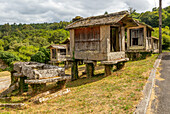
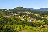
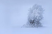
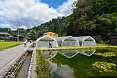
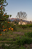
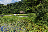
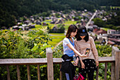
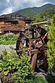
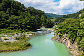
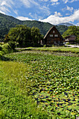
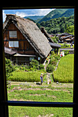
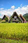
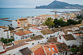
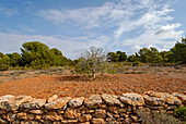
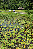
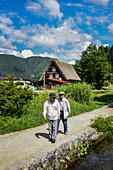
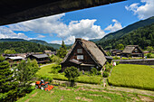
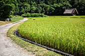
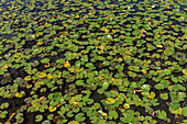
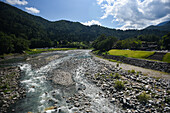
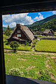
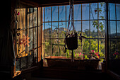
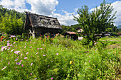
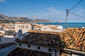
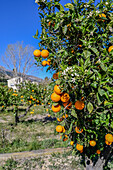
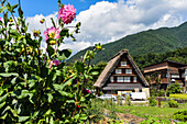
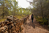
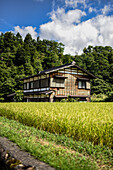
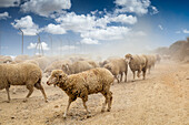
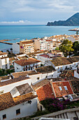
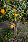
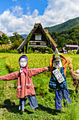
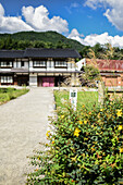
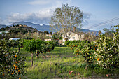
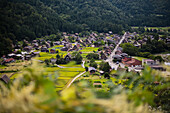
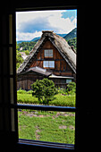
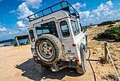
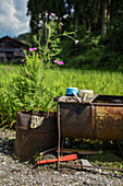
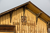
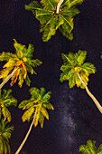
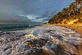
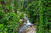
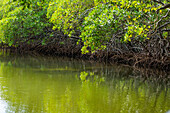
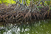
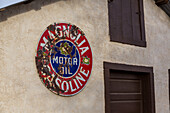
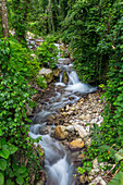
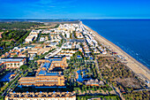
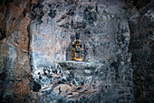
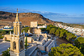
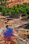
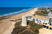
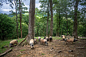
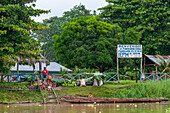
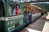
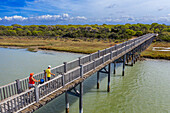
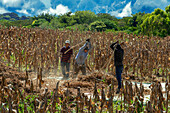
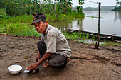
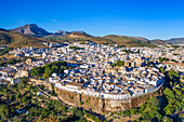
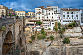
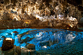
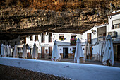
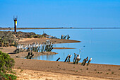
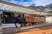
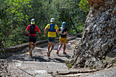
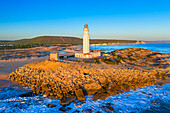
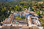
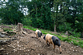
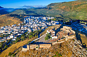
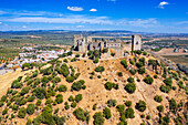
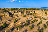
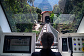
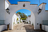
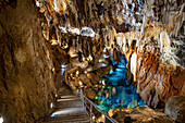
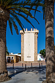
Images

Paysannes Photos ❘ lookphotos

 at the Karerpass with Rosengarten, South Tyrol, Italy
71498182 - at the Karerpass with Rosengarten, South Tyrol, Italy
 Picturesque village in the vineyards by the lake, Rivaz, Lavaux, UNESCO World Heritage Site, Lake Geneva, Lac Léman, Canton of Vaud, Switzerland
71497889 - Picturesque village in the vineyards by the lake, Rivaz, Lavaux, UNESCO World Heritage Site, Lake Geneva, Lac Léman, Canton of Vaud, Switzerland
 Picturesque village in the vineyards by the lake, Saint-Saphorin, Lavaux, UNESCO World Heritage Site, Lake Geneva, Lac Léman, Canton of Vaud, Switzerland
71497871 - Picturesque village in the vineyards by the lake, Saint-Saphorin, Lavaux, UNESCO World Heritage Site, Lake Geneva, Lac Léman, Canton of Vaud, Switzerland
 Oberstaufen, Allgäu, Bavaria, Germany
71497770 - Oberstaufen, Allgäu, Bavaria, Germany
 Gestratz, Westallgäu, Swabia, Bavaria, Germany
71497750 - Gestratz, Westallgäu, Swabia, Bavaria, Germany
 Landscape near Hopferau, Allgäu, Swabia, Bavaria, Germany
71497666 - Landscape near Hopferau, Allgäu, Swabia, Bavaria, Germany
 Landscape near Hopferau, Allgäu, Swabia, Bavaria, Germany
71497662 - Landscape near Hopferau, Allgäu, Swabia, Bavaria, Germany
 Animals on the farm of the Ferienhof Kinker in Ussenburg, a district of Roßhaupten, Allgäu, Swabia, Bavaria, Germany
71497640 - Animals on the farm of the Ferienhof Kinker in Ussenburg, a district of Roßhaupten, Allgäu, Swabia, Bavaria, Germany
 Landscape near Ussenburg, a district of Roßhaupten, Allgäu, Swabia, Bavaria, Germany
71497630 - Landscape near Ussenburg, a district of Roßhaupten, Allgäu, Swabia, Bavaria, Germany
H'mong farmers family coming back from fields, near Dong Van, Ha Giang province, Northern Vietnam, Southeast Asia
71496919 - H'mong farmers family coming back from fields, near Dong Van, Ha Giang province, Northern Vietnam, Southeast Asia
Road to Dong Van, Ha Giang province, Northern Vietnam, Southeast Asia
71496917 - Road to Dong Van, Ha Giang province, Northern Vietnam, Southeast Asia
Auberge du Sombral, Saint-Cirq-Lapopie, one of the
71496848 - Auberge du Sombral, Saint-Cirq-Lapopie, one of the
Shepherd and flock of sheep on the Causse de Campestre,Southern Cevennes,Gard department,Languedoc-Roussillon region,France,Europe
71496831 - Shepherd and flock of sheep on the Causse de Campestre,Southern Cevennes,Gard department,Languedoc-Roussillon region,France,Europe
Castle of Mandagout,guesthouse near Le Vigan,Cevennes Mountains Range,Gard department,Languedoc- Roussillon region,France,Europe
71496827 - Castle of Mandagout,guesthouse near Le Vigan,Cevennes Mountains Range,Gard department,Languedoc- Roussillon region,France,Europe
Aumessas, village of Cevennes,Gard department,Languedoc-Roussillon region,France,Europe
71496820 - Aumessas, village of Cevennes,Gard department,Languedoc-Roussillon region,France,Europe
Horse from Camargue,Grau du Roi,Gard department,France,Europe
71496815 - Horse from Camargue,Grau du Roi,Gard department,France,Europe
Cattle in Aubrac plateau,Lozere departement,Languedoc-Roussillon region,Occitanie,France,Europe
71496772 - Cattle in Aubrac plateau,Lozere departement,Languedoc-Roussillon region,Occitanie,France,Europe
almost mature flax field with seed capsules, Centre-Val de Loire region, France, Europe
71496750 - almost mature flax field with seed capsules, Centre-Val de Loire region, France, Europe
Windmill called Pelard at Bouville, Beauce, Eure-et-Loir department, Centre-Val-de-Loire region, France, Europe
71496748 - Windmill called Pelard at Bouville, Beauce, Eure-et-Loir department, Centre-Val-de-Loire region, France, Europe
La Maltorne small river at Senantes, Eure-et-Loir department , Centre-Val de Loire region, France, Europe
71496737 - La Maltorne small river at Senantes, Eure-et-Loir department , Centre-Val de Loire region, France, Europe
flax field flowering, Centre-Val de Loire region, France, Europe
71496735 - flax field flowering, Centre-Val de Loire region, France, Europe
Swimming pool at Terra do Sempre guesthouse near Grandola, Alentejo region, Portugal, southwertern Europe
71496672 - Swimming pool at Terra do Sempre guesthouse near Grandola, Alentejo region, Portugal, southwertern Europe
Perched village Monsaraz, Municipality of Reguengos de Monsaraz, Alentejo region, Portugal, southwertern Europe
71496647 - Perched village Monsaraz, Municipality of Reguengos de Monsaraz, Alentejo region, Portugal, southwertern Europe
Perched village Monsaraz, Municipality of Reguengos de Monsaraz, Alentejo region, Portugal, southwertern Europe
71496639 - Perched village Monsaraz, Municipality of Reguengos de Monsaraz, Alentejo region, Portugal, southwertern Europe
Village of Quintao, Municipality of Mertola, Alentejo region, Portugal, southwertern Europe
71496630 - Village of Quintao, Municipality of Mertola, Alentejo region, Portugal, southwertern Europe
 European hare, Lepus europaeus, in a rapeseed field, Schleswig-Holstein, Germany
71496255 - European hare, Lepus europaeus, in a rapeseed field, Schleswig-Holstein, Germany
 European hare, Lepus europaeus, running hare, spring, Schleswig-Holstein, Germany
71496253 - European hare, Lepus europaeus, running hare, spring, Schleswig-Holstein, Germany
 European hare, Lepus europaeus, mating hares, Schleswig-Holstein, Germany
71496251 - European hare, Lepus europaeus, mating hares, Schleswig-Holstein, Germany
 European hare, Lepus europaeus, in a flower meadow, Schleswig-Holstein, Germany
71496247 - European hare, Lepus europaeus, in a flower meadow, Schleswig-Holstein, Germany
 View of Pienza, Val d'Orcia, Tuscany, Italy
71496112 - View of Pienza, Val d'Orcia, Tuscany, Italy
 The Madonna di Vitaleta chapel near Pienza, Val d'Orcia, Tuscany, Italy
71496106 - The Madonna di Vitaleta chapel near Pienza, Val d'Orcia, Tuscany, Italy
 Casa Rossa Ximenes in the Diaccia Botronca Nature Reserve, Tuscany, Italy
71496029 - Casa Rossa Ximenes in the Diaccia Botronca Nature Reserve, Tuscany, Italy
 Cypress grove "I Cipressi" in the Orcia Valley, Val d'Orcia, Tuscany, Italy
71495999 - Cypress grove "I Cipressi" in the Orcia Valley, Val d'Orcia, Tuscany, Italy
 In the Orcia Valley, Val d'Orcia, Tuscany, Italy
71495995 - In the Orcia Valley, Val d'Orcia, Tuscany, Italy
 View over the Orcia Valley from Pienza towards Monte Amiata, Val d'Orcia, Tuscany, Italy
71495976 - View over the Orcia Valley from Pienza towards Monte Amiata, Val d'Orcia, Tuscany, Italy
 View over the Orcia Valley from Pienza towards Monte Amiata, Val d'Orcia, Tuscany, Italy
71495974 - View over the Orcia Valley from Pienza towards Monte Amiata, Val d'Orcia, Tuscany, Italy
 The La Sesta winery in Val d'orcia, Tuscany, Italy
71495950 - The La Sesta winery in Val d'orcia, Tuscany, Italy
 View towards Castelnuovo dell'Abate, Val d'Orcia, Tuscany, Italy
71495949 - View towards Castelnuovo dell'Abate, Val d'Orcia, Tuscany, Italy
 Stork's nest on a building in Giethoorn, Netherlands
71495874 - Stork's nest on a building in Giethoorn, Netherlands
Betancuria Natural Park, Fuerteventura, Canary Islands, Spain
71495625 - Betancuria Natural Park, Fuerteventura, Canary Islands, Spain
Road going through Fuerteventura island arid landscape, Fuerteventura, Canary Islands, Spain
71495611 - Road going through Fuerteventura island arid landscape, Fuerteventura, Canary Islands, Spain
 Autumn, Lower Rhine, trees, fog, sun, backlight, morning
71495507 - Autumn, Lower Rhine, trees, fog, sun, backlight, morning
Pouilly-Fuisse vineyards at the foot of the Rock of Vergisson, Saone et Loire department,Burgundy region,France,Europe
71493548 - Pouilly-Fuisse vineyards at the foot of the Rock of Vergisson, Saone et Loire department,Burgundy region,France,Europe
Castle of Cormatin,Saone et Loire department,Burgundy region,France,Europe
71493545 - Castle of Cormatin,Saone et Loire department,Burgundy region,France,Europe
Gabriere pond,Regional nature Park of Brenne,Indre department,province of Berry,region of Centre,France,Europe
71493529 - Gabriere pond,Regional nature Park of Brenne,Indre department,province of Berry,region of Centre,France,Europe
Saint-Emilion,Gironde department,Aquitaine region,south-western France,Europe
71493481 - Saint-Emilion,Gironde department,Aquitaine region,south-western France,Europe
Vineyard of the village of Neac under wine label Lalande de Pomerol,Gironde department,Aquitaine region,south-western France,Europe
71493475 - Vineyard of the village of Neac under wine label Lalande de Pomerol,Gironde department,Aquitaine region,south-western France,Europe
Cabernet grapes,vineyard in Pomerol,Gironde department,Aquitaine region,south-western France,Europe
71493473 - Cabernet grapes,vineyard in Pomerol,Gironde department,Aquitaine region,south-western France,Europe
Wine growing estate Chateau Gazin,Pomerol,Gironde department,Aquitaine region,south-western France,Europe
71493472 - Wine growing estate Chateau Gazin,Pomerol,Gironde department,Aquitaine region,south-western France,Europe
 Field barn in winter, Kochelmoos, Schlehdorf, Upper Bavaria, Bavaria, Germany
71491825 - Field barn in winter, Kochelmoos, Schlehdorf, Upper Bavaria, Bavaria, Germany
 Landscape with prickly pears and olive trees overlooking the Djebel Chambi des Dorsale mountain range near Sbeitla, Tunisia
71486680 - Landscape with prickly pears and olive trees overlooking the Djebel Chambi des Dorsale mountain range near Sbeitla, Tunisia
 Field barn in Kochelmoos, Schlehdorf, Upper Bavaria, Bavaria, Germany
71484667 - Field barn in Kochelmoos, Schlehdorf, Upper Bavaria, Bavaria, Germany
Scenic view of flooded Jatiluwih Rice Terraces using traditional Subak irrigation system and recognized as UNESCO Cultural Landscape. Bali, Indonesia.
71484585 - Scenic view of flooded Jatiluwih Rice Terraces using traditional Subak irrigation system and recognized as UNESCO Cultural Landscape. Bali, Indonesia.
 Old olive trees on the path between Es Capdella and Finca Publica Galatzo, Mallorca, Balearic Islands, Spain
71483817 - Old olive trees on the path between Es Capdella and Finca Publica Galatzo, Mallorca, Balearic Islands, Spain
 View from the Western Way hiking trail over rural Ireland at Lough Corrib, County Galway, Ireland
71483274 - View from the Western Way hiking trail over rural Ireland at Lough Corrib, County Galway, Ireland
Windmill, Formentera, Balearic Islands, Spain
71483072 - Windmill, Formentera, Balearic Islands, Spain
Typical house in the village of Ban Pha Yong, where live people from both Khmu and Hmong minority ethnics groups,  in mountain massif near Nong Khiaw, Luang Prabang Province, Laos, Southeast Asia
71481804 - Typical house in the village of Ban Pha Yong, where live people from both Khmu and Hmong minority ethnics groups, in mountain massif near Nong Khiaw, Luang Prabang Province, Laos, Southeast Asia
Foot activated lever pestle in the village of Ban Pha Yong, where live people from both Khmu and Hmong minority ethnics groups,  in mountain massif near Nong Khiaw, Luang Prabang Province, Laos, Southeast Asia
71481803 - Foot activated lever pestle in the village of Ban Pha Yong, where live people from both Khmu and Hmong minority ethnics groups, in mountain massif near Nong Khiaw, Luang Prabang Province, Laos, Southeast Asia
Rock formation shaped like a boot, Punakaiki, Paparoa National Park, South Island, New Zealand
71481305 - Rock formation shaped like a boot, Punakaiki, Paparoa National Park, South Island, New Zealand
road marking for shared car and cycle lane near the village of Valdaora di Sotto (German:Niederolang)Trentino-Alto Adige, Sudtyrol, South Tyrol, Italy, South-central Europe
71478367 - road marking for shared car and cycle lane near the village of Valdaora di Sotto (German:Niederolang)Trentino-Alto Adige, Sudtyrol, South Tyrol, Italy, South-central Europe
A vibrant rainbow arches over a green landscape under a dramatic sky filled with dark clouds. The scene captures the contrast between the colorful rainbow and the moody weather, with a road leading into the distance.
71477024 - A vibrant rainbow arches over a green landscape under a dramatic sky filled with dark clouds. The scene captures the contrast between the colorful rainbow and the moody weather, with a road leading into the distance.
A cyclist arrives at Cubillos, Soria, with red panniers resting beside the sign, enjoying the quiet of forgotten ruins in summer.
14625172 - A cyclist arrives at Cubillos, Soria, with red panniers resting beside the sign, enjoying the quiet of forgotten ruins in summer.
Parade of peasants and locals in traditional clothing in Salento, Quindio, Colombia
14624847 - Parade of peasants and locals in traditional clothing in Salento, Quindio, Colombia
An ancient olive tree stands tall in the fertile countryside of Seville, Andalusia, showcasing its twisted bark and vibrant foliage.
14624375 - An ancient olive tree stands tall in the fertile countryside of Seville, Andalusia, showcasing its twisted bark and vibrant foliage.
Tudanca cows with grey coats peacefully graze in the lush pastures of Pechon, Cantabria, showcasing their unique curved horns.
14623998 - Tudanca cows with grey coats peacefully graze in the lush pastures of Pechon, Cantabria, showcasing their unique curved horns.
A bright yellow granary is surrounded by flooded rice fields after harvest in Isla Mayor, Seville, showcasing the beauty of this landscape.
14623882 - A bright yellow granary is surrounded by flooded rice fields after harvest in Isla Mayor, Seville, showcasing the beauty of this landscape.
Osuna showcases its whitewashed buildings and green landscapes under a bright blue sky, illustrating the charm of Andalusia's architecture.
14623856 - Osuna showcases its whitewashed buildings and green landscapes under a bright blue sky, illustrating the charm of Andalusia's architecture.
A detailed view of a vine stock in winter showcases modern cultivation techniques in the vineyards of Carrión de los Céspedes.
14622500 - A detailed view of a vine stock in winter showcases modern cultivation techniques in the vineyards of Carrión de los Céspedes.
A solitary mountain refuge stands on a vast landscape in Los Campos de Hernán Pelea, offering a peaceful retreat in Andalusia.
14622337 - A solitary mountain refuge stands on a vast landscape in Los Campos de Hernán Pelea, offering a peaceful retreat in Andalusia.
Pallares, Spain, Aug 28 2025, In Pallares, Badajoz, a gardener meticulously cares for summer crops, surrounded by stone walls and the tranquility of the countryside.
14622039 - Pallares, Spain, Aug 28 2025, In Pallares, Badajoz, a gardener meticulously cares for summer crops, surrounded by stone walls and the tranquility of the countryside.
Ancient rusted water wheel in Pallares, Badajoz, showcasing engineering of irrigation systems once vital for local agriculture.
14621856 - Ancient rusted water wheel in Pallares, Badajoz, showcasing engineering of irrigation systems once vital for local agriculture.
Parade of peasants and locals in traditional clothing in Salento, Quindio, Colombia
14621474 - Parade of peasants and locals in traditional clothing in Salento, Quindio, Colombia
A lone cyclist stops to admire the arched remains of the 12th-century San Juan Bautista hermitage in Calatanazor, Castilla y Leon.
14621428 - A lone cyclist stops to admire the arched remains of the 12th-century San Juan Bautista hermitage in Calatanazor, Castilla y Leon.
Carrión, Spain, Jan 21 2019, Blue tractor by long white red building, blue posts. Carrion, Seville, Andalusia, Spain.
14621356 - Carrión, Spain, Jan 21 2019, Blue tractor by long white red building, blue posts. Carrion, Seville, Andalusia, Spain.
A goalpost stands on a dirt football field in Carrión de los Céspedes, Seville. The rural setting offers a quiet, scenic backdrop for play.
14482927 - A goalpost stands on a dirt football field in Carrión de los Céspedes, Seville. The rural setting offers a quiet, scenic backdrop for play.
Freshly turned soil stretches across the countryside of Seville, surrounded by lush greenery and trees under a clear blue sky.
14482836 - Freshly turned soil stretches across the countryside of Seville, surrounded by lush greenery and trees under a clear blue sky.
A tree trunk rests in the riverbed of the Tinto River, exhibiting the reddish hues from mineralization beside an ancient Roman bridge.
14482711 - A tree trunk rests in the riverbed of the Tinto River, exhibiting the reddish hues from mineralization beside an ancient Roman bridge.
Colibrí Paramuno, Shining Sunbeam, Aglaeactis cupripennis
14482618 - Colibrí Paramuno, Shining Sunbeam, Aglaeactis cupripennis
Espeletia santanderensis. .
14482602 - Espeletia santanderensis. .
The Páramo del Almorzadero, located in the Eastern mountain range of the Colombian Andes, between the departments of Santander and Norte de Santander, is a vital high mountain ecosystem for the region. With altitudes that exceed 4,300 meters, this páramo is home to a unique biodiversity, highlighting the frailejones, mosses and lichens adapted to the extreme cold and frequent fogs. Its numerous lagoons and wetlands are the source of important rivers that supply water to local communities and agricultural activities. In addition, it is a refuge for species such as the Andean condor and endemic
14482375 - The Páramo del Almorzadero, located in the Eastern mountain range of the Colombian Andes, between the departments of Santander and Norte de Santander, is a vital high mountain ecosystem for the region. With altitudes that exceed 4,300 meters, this páramo is home to a unique biodiversity, highlighting the frailejones, mosses and lichens adapted to the extreme cold and frequent fogs. Its numerous lagoons and wetlands are the source of important rivers that supply water to local communities and agricultural activities. In addition, it is a refuge for species such as the Andean condor and endemic
The municipality of Santo Domingo de Silos is located in the department of Norte de Santander, in the northeast of Colombia. Geographically, it is located in the Eastern Andes mountain range, at an altitude of approximately 2,850 meters above sea level. It borders municipalities such as Pamplona, ??Chitagá, Mutiscua and Cácota, in an area characterized by mountainous landscapes, moorlands and agricultural activities. It is part of the Santurbán Páramo, a water source for Santander and Norte de Santander.
14482367 - The municipality of Santo Domingo de Silos is located in the department of Norte de Santander, in the northeast of Colombia. Geographically, it is located in the Eastern Andes mountain range, at an altitude of approximately 2,850 meters above sea level. It borders municipalities such as Pamplona, ??Chitagá, Mutiscua and Cácota, in an area characterized by mountainous landscapes, moorlands and agricultural activities. It is part of the Santurbán Páramo, a water source for Santander and Norte de Santander.
In Medellin, paragliding is practiced in strategic areas outside the urban area, such as Altos de San Félix and Matasanos. These areas, located on the outskirts of the city, have ideal climatic and topographic conditions for flying and enjoying impressive panoramic views of the Aburrá Valley, the slopes of the city of Medellin and the municipality of Bello, a town near this city.
14482338 - In Medellin, paragliding is practiced in strategic areas outside the urban area, such as Altos de San Félix and Matasanos. These areas, located on the outskirts of the city, have ideal climatic and topographic conditions for flying and enjoying impressive panoramic views of the Aburrá Valley, the slopes of the city of Medellin and the municipality of Bello, a town near this city.
In Medellin, paragliding is practiced in strategic areas outside the urban area, such as Altos de San Félix and Matasanos. These areas, located on the outskirts of the city, have ideal climatic and topographic conditions for flying and enjoying impressive panoramic views of the Aburrá Valley, the slopes of the city of Medellin and the municipality of Bello, a town near this city.
14482257 - In Medellin, paragliding is practiced in strategic areas outside the urban area, such as Altos de San Félix and Matasanos. These areas, located on the outskirts of the city, have ideal climatic and topographic conditions for flying and enjoying impressive panoramic views of the Aburrá Valley, the slopes of the city of Medellin and the municipality of Bello, a town near this city.
The Páramo del Almorzadero, located in the Eastern mountain range of the Colombian Andes, between the departments of Santander and Norte de Santander, is a vital high mountain ecosystem for the region. With altitudes that exceed 4,300 meters, this páramo is home to a unique biodiversity, highlighting the frailejones, mosses and lichens adapted to the extreme cold and frequent fogs. Its numerous lagoons and wetlands are the source of important rivers that supply water to local communities and agricultural activities. In addition, it is a refuge for species such as the Andean condor and endemic
14482202 - The Páramo del Almorzadero, located in the Eastern mountain range of the Colombian Andes, between the departments of Santander and Norte de Santander, is a vital high mountain ecosystem for the region. With altitudes that exceed 4,300 meters, this páramo is home to a unique biodiversity, highlighting the frailejones, mosses and lichens adapted to the extreme cold and frequent fogs. Its numerous lagoons and wetlands are the source of important rivers that supply water to local communities and agricultural activities. In addition, it is a refuge for species such as the Andean condor and endemic
Sun shade structures protect sensitive crops in the agricultural land around Guatape, Colombia.
14482127 - Sun shade structures protect sensitive crops in the agricultural land around Guatape, Colombia.
Couples participating in the gaita dance competition.
14482067 - Couples participating in the gaita dance competition.
María Isabel García, one of the last artisans of the Tuaté pottery technique, a technique inherited from the indigenous people who bore the same name.
14482008 - María Isabel García, one of the last artisans of the Tuaté pottery technique, a technique inherited from the indigenous people who bore the same name.
The Lagunas Negras Trail, located in the municipality of Vetas, Santander, is a hiking route located in the Páramo de Santurbán. It is a route with high mountain landscapes, characterized by impressive rock formations and lagoons of glacial origin with the presence of fauna and flora subject to conservation, among them is the endemic species of frailejon, Espeletia santanderensis.
14481879 - The Lagunas Negras Trail, located in the municipality of Vetas, Santander, is a hiking route located in the Páramo de Santurbán. It is a route with high mountain landscapes, characterized by impressive rock formations and lagoons of glacial origin with the presence of fauna and flora subject to conservation, among them is the endemic species of frailejon, Espeletia santanderensis.
Cácota is a municipality located in the department of Norte de Santander, in the northeastern region of Colombia. With a rich history dating back to colonial times, this place has kept alive traditions that reflect the fusion between indigenous roots and Spanish heritage. Its natural environment, characterised by landscapes that combine agricultural areas and areas of native vegetation. The architecture of its buildings shows a deep cultural legacy.
14481787 - Cácota is a municipality located in the department of Norte de Santander, in the northeastern region of Colombia. With a rich history dating back to colonial times, this place has kept alive traditions that reflect the fusion between indigenous roots and Spanish heritage. Its natural environment, characterised by landscapes that combine agricultural areas and areas of native vegetation. The architecture of its buildings shows a deep cultural legacy.
Peasants starting their work day.
14481771 - Peasants starting their work day.
The municipality of Santo Domingo de Silos is located in the department of Norte de Santander, in the northeast of Colombia. Geographically, it is located in the Eastern Andes mountain range, at an altitude of approximately 2,850 meters above sea level. It borders municipalities such as Pamplona, ??Chitagá, Mutiscua and Cácota, in an area characterized by mountainous landscapes, moorlands and agricultural activities. It is part of the Santurbán Páramo, a water source for Santander and Norte de Santander.
14481651 - The municipality of Santo Domingo de Silos is located in the department of Norte de Santander, in the northeast of Colombia. Geographically, it is located in the Eastern Andes mountain range, at an altitude of approximately 2,850 meters above sea level. It borders municipalities such as Pamplona, ??Chitagá, Mutiscua and Cácota, in an area characterized by mountainous landscapes, moorlands and agricultural activities. It is part of the Santurbán Páramo, a water source for Santander and Norte de Santander.
Espeletia santanderensis. .
14481456 - Espeletia santanderensis. .
The municipality of Chitaga is located in the department of Norte de Santander, in the northeast of Colombia. Geographically, it is located in the Andean region, at an altitude of 2,300 meters above sea level, within the high plateau of the Eastern Andes mountain range. It borders municipalities such as Pamplona, ??Silos and Cácota, and is part of an area characterized by mooslands and rural areas dedicated to agriculture and livestock. It is part of the Paramo de Santurbán, a water source for Santander and Norte de Santander.
14481395 - The municipality of Chitaga is located in the department of Norte de Santander, in the northeast of Colombia. Geographically, it is located in the Andean region, at an altitude of 2,300 meters above sea level, within the high plateau of the Eastern Andes mountain range. It borders municipalities such as Pamplona, ??Silos and Cácota, and is part of an area characterized by mooslands and rural areas dedicated to agriculture and livestock. It is part of the Paramo de Santurbán, a water source for Santander and Norte de Santander.
Main square and principal church, Cerinza town
14481370 - Main square and principal church, Cerinza town
Parroquia San Juan Nepomuceno.
14481257 - Parroquia San Juan Nepomuceno.
In Medellin, paragliding is practiced in strategic areas outside the urban area, such as Altos de San Félix and Matasanos. These areas, located on the outskirts of the city, have ideal climatic and topographic conditions for flying and enjoying impressive panoramic views of the Aburrá Valley, the slopes of the city of Medellin and the municipality of Bello, a town near this city.
14481174 - In Medellin, paragliding is practiced in strategic areas outside the urban area, such as Altos de San Félix and Matasanos. These areas, located on the outskirts of the city, have ideal climatic and topographic conditions for flying and enjoying impressive panoramic views of the Aburrá Valley, the slopes of the city of Medellin and the municipality of Bello, a town near this city.
Children's gaita group dressed in traditional costumes.
14481117 - Children's gaita group dressed in traditional costumes.
Espeletia santanderensis. .
14481101 - Espeletia santanderensis. .
The Lagunas Negras Trail, located in the municipality of Vetas, Santander, is a hiking route located in the Páramo de Santurbán. It is a route with high mountain landscapes, characterized by impressive rock formations and lagoons of glacial origin with the presence of fauna and flora subject to conservation, among them is the endemic species of frailejon, Espeletia santanderensis.
14481078 - The Lagunas Negras Trail, located in the municipality of Vetas, Santander, is a hiking route located in the Páramo de Santurbán. It is a route with high mountain landscapes, characterized by impressive rock formations and lagoons of glacial origin with the presence of fauna and flora subject to conservation, among them is the endemic species of frailejon, Espeletia santanderensis.
page suivante