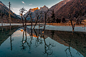
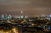
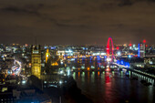
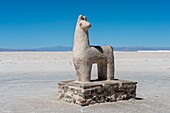
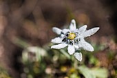
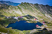
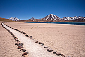
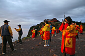
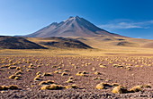
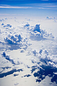
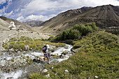
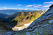
13883390 - Sunset with trees reflected in a high altitude lake on the Tibetan Plateau; Rilong, Sichuan Province, China13772586 - London Views From Altitude 360, Millbank Tower; London, England13772585 - London Views From Altitude 360, Millbank Tower; London, England71399302 - A llama statue carved out of salt at Salinas Grandes a salt pan in the Andes Mountains - is situated on an altitude of 3. 450 meters on the border of the provinces of Salta and Jujuy,Argentina.71359142 - Italy, Piedmont, Valle Varaita, Becetto, Cima Crosa. Edelweiss to born on rocks at high altitude in Valle Varaita.71367628 - Elevated view over Balea Lake at 2034m altitude in the Fagaras Mountains in central Romania, Cartisoara, Sibiu County, Romania, Europe71367625 - Elevated view over Balea Lake at 2034m altitude in the Fagaras Mountains in central Romania, Cartisoara, Sibiu County, Romania, Europe71358874 - Path to Laguna Miscanti, a brackish lake at an altitude of 4140 meters in the Andean Central Volcanic Zone, Chile, South America71338342 - Sunset over landscape at the "Roque Nublo" monolith in the high mountains of Gran Canaria (1813 m altitude, Spain71338339 - "Roque Nublo" monolith in the high mountains of Gran Canaria (1813 m altitude) in the evening light, Spain71338336 - At the "Roque Nublo" monolith in the high mountains of Gran Canaria (1813 m altitude) in the evening light, Spain70056830 - pilgrims and tourists, early morning sunrise and sea of clouds, 3077 metre altitude, Golden Summit, summit of Emei Shan mountains, World Heritage Site, UNESCO, China, Asia71338344 - View from "Roque Nublo" plateau in the high mountains of Gran Canaria (1813 m altitude) on Teide volcano (Tenerife) at sunset, Spain71338341 - View from the "Roque Nublo" monolith in the high mountains of Gran Canaria (1813 m altitude) on Teide volcano (Tenerife) in the evening light, Spain71338338 - View from the "Roque Nublo" monolith in the high mountains of Gran Canaria (1813 m altitude) in the evening light, Spain71338337 - View from the "Roque Nublo" monolith in the high mountains of Gran Canaria (1813 m altitude) on Teide volcano (Tenerife) in the evening light, Spain71338343 - Landscape at the "Roque Nublo" monolith in the high mountains of Gran Canaria (1813 m altitude) in the sunset, Spain71321147 - Detailed view of the Petronas Towers, Kuala Lumpur, Malaysia from a high altitude71168364 - 'Gornergrat observatory, the second highest observatory in Europe, High Altitude research station; Switzerland'71196588 - The Tierser Alp hut at an altitude of 2440m in the Seiser Alm area after sunrise, Siusi, South Tyrol, Alto Adige, Italy71345551 - A llama statue carved out of salt at Salinas Grandes a salt pan in the Andes Mountains - is situated on an altitude of 3.450 meters on the border of the provinces of Salta and Jujuy, Argentina.71045662 - Laguna Miscanti at an altitude of 4300m and the peak of Cerro Miscanti at 5622m, Los Flamencos National Reserve, Atacama Desert, Antofagasta Region, Norte Grande, Chile, South America70171206 - Aerial, Aerials, Air flight, Aircraft, Airplane, Altitude, Atlantic, Aviation, Blue, Calm, Cloud formation, Cloud formations, Clouds, Color, Colour, Commercial, Concept, Concepts, Conceptual, Cumulus, Earth, Engine, Engines, Flight, Flights, Flying, Glob70155792 - Aeroplane, Aeroplanes, Air, Aircraft, Aircrafts, Airliner, Airliners, Airplane, Airplanes, Altitude, Cloud, Clouds, Color, Colour, Detail, Details, Exterior, Flight, Flights, Fly, Flying, Height, Holiday, Holidays, Horizontal, Lift, One, Outdoor, Outdoor71345607 - Salinas Grandes a salt pan in the Andes Mountains - is situated on an altitude of 3.450 meters on the border of the provinces of Salta and Jujuy, Argentina.71345552 - Salt mining at Salinas Grandes a salt pan in the Andes Mountains - is situated on an altitude of 3.450 meters on the border of the provinces of Salta and Jujuy, Argentina.70448300 - Giant Groundsel or Dendrosenecio senecio keniodendron in the Mount Kenya National Park, Kenya, with withered inflorescense Giant Groundsel is endemic to the afromontane high altitude environments of Africas highest mountains It is well adapted to the hi70137837 - Aerodynamic, Aeroplane, Aeroplanes, Air, Aircraft, Aircrafts, Airliner, Airliners, Airplane, Airplanes, Altitude, Atmosphere, Cloud, Clouds, Color, Colour, Daytime, Detail, Details, Engine, Engines, Flight, Flights, Fly, Flying, Height, Horizontal, Indoo71345604 - Salt mining at Salinas Grandes a salt pan in the Andes Mountains - is situated on an altitude of 3.450 meters on the border of the provinces of Salta and Jujuy, Argentina.71319823 - A climber at Everest Base Camp the day after he has successfully summited Everest shows the signs of exposure at high altitude, Khumbu, Nepal, Asia70448301 - Giant Groundsel or Dendrosenecio senecio keniodendron in the Mount Kenya National Park, Kenya, detail of the rosette of a young plant Giant Groundsel is endemic to the afromontane high altitude environments of Africas highest mountains It is well adapte70205482 - Altitude, Autumn, Autumnal, Brown, Color, Colored, Colorful, Colors, Colour, Coloured, Colourful, Colours, Concept, Concepts, Daytime, Exterior, Fall, Foliage, Height, Horizontal, Leaf, Leaves, Low angle view, Nature, Outdoor, Outdoors, Outside, Plant, Pl70153031 - Aeroplane, Aeroplanes, Air, Aircraft, Aircrafts, Airplane, Airplanes, Altitude, Blue sky, Color, Colour, Condensation trail, Contrail, Contrails, Exterior, Fast, Flight, Flights, Fly, Flying, Height, Horizontal, Motion, Movement, Outdoor, Outdoors, Outsi71345606 - Salt mining at Salinas Grandes a salt pan in the Andes Mountains - is situated on an altitude of 3.450 meters on the border of the provinces of Salta and Jujuy, Argentina.71345554 - Salt crystals floating on the pools of the salt mining operation at Salinas Grandes, a salt pan in the Andes Mountains - is situated on an altitude of 3.450 meters on the border of the provinces of Salta and Jujuy, Argentina.71045664 - The altiplano at an altitude of over 4000m looking over the salt lake Laguna de Tuyajto, Los Flamencos National Reserve, Atacama Desert, Antofagasta Region, Norte Grande, Chile, South America70288891 - Absolute, Abstract, Abstraction, Action, Activity, Air, Altitude, Appease, Atmosphere, Attitude, Beam, Beauty, Blanke, Blur, Blurred, Blurry, Breath, Calm, Calmness, Car, Cars, City, Clarity, Clear, Clearance, Clemency, Cluster, Color, Colored, Colour, Co70182852 - Aeroplane, Aeroplanes, Aircraft, Aircrafts, Airplane, Airplanes, Altitude, Blue, Blue sky, Building, Buildings, Color, Colour, Condensation trail, Contrail, Contrails, Daytime, Detail, Details, Exterior, Flat roof, Flat roofs, Free, Freedom, Height, Horiz70153032 - Aeroplane, Aeroplanes, Air, Aircraft, Aircrafts, Airplane, Airplanes, Altitude, Blue sky, Color, Colour, Condensation trail, Contrail, Contrails, Exterior, Fast, Flight, Flights, Fly, Flying, Height, Horizontal, Motion, Movement, Outdoor, Outdoors, Outsi70097633 - Aerodynamic, Aeroplane, Aeroplanes, Air, Aircraft, Aircrafts, Airliner, Airliners, Airplane, Airplanes, Altitude, Blue, Blue sky, Cloud, Clouds, Color, Colour, Contemporary, Detail, Details, Engine, Engines, Exterior, Flight, Flights, Fly, Flying, Height71345713 - Camping at hight altitude with Matterhorn (Cervino) on background, Gobba di Rollin, Monte Rosa, Aosta Valley, Italy71345605 - Salt mining at Salinas Grandes a salt pan in the Andes Mountains - is situated on an altitude of 3.450 meters on the border of the provinces of Salta and Jujuy, Argentina.71345553 - Salt mining at Salinas Grandes a salt pan in the Andes Mountains - is situated on an altitude of 3.450 meters on the border of the provinces of Salta and Jujuy, Argentina.71345550 - A llama statue carved out of salt at Salinas Grandes a salt pan in the Andes Mountains - is situated on an altitude of 3.450 meters on the border of the provinces of Salta and Jujuy, Argentina.71319518 - The altiplano at an altitude of over 4000m and the peak of Cerro Miniques at 5910m, Los Flamencos National Reserve, Atacama Desert, Antofagasta Region, Norte Grande, Chile, South America70171207 - Aerial, Aerials, Aircraft, Airplane, Altitude, Atlantic, Aviation, Blue, Calm, Cloud formation, Cloud formations, Clouds, Color, Colour, Concept, Concepts, Conceptual, Cumulus, Earth, Flight, Flying, Globe, Holidays, In flight, Jet, Motor, Plane, Reflect70501477 - Caucasian woman crosses creek during trek in Zanskar Mountain Range of Ladakh, northern India. The high altitude area is popular with trekkers because of its Buddhist and Muslim cultural heritage and its stunning scenery71317232 - Flock of sheep at high altitude, Valgerola, Orobie Alps, Valtellina, Lombardy, Italy, Europe71045666 - The altiplano at an altitude of over 4000m looking over the salt lake Laguna de Tuyajto, Los Flamencos National Reserve, Atacama Desert, Antofagasta Region, Norte Grande, Chile, South America71045665 - The altiplano at an altitude of over 4000m looking over the salt lake Laguna de Tuyajto, Los Flamencos National Reserve, Atacama Desert, Antofagasta Region, Norte Grande, Chile, South America71217903 - India, Jammu and Kashmir State, Himalaya, Ladakh, high-altitude plateau of Changthang (Changtang), rainbow and Tso Moriri lake (4530m)71155381 - Altitude sign, Badwater Basin, Death Valley National Park, Inyo County, California, USA13899379 - This is a moonlit nightscape of the historic Hearst Church in Pinos Altos, New Mexico, at 7000 feet altitude (thus the name “High Pines”) and on the Continental Divide. In the sky above, the Big Dipper is at right, and Polaris is at left over the church.13900301 - A 150° panorama of the auroral arc across the northern sky, shot from home in Alberta on April 27, 2022. The camera picked up the blue colour at the top of the curtains at left in the northwest from high-altitude sunlight illuminating the tops of the curtains. Otherwise, oxygen reds and greens dominate this fairly quiet display. Coincidentally, the arc of the aurora nicely follows the arc of the Milky Way across the north, then at its lowest for the year in the spring sky.13877327 - Chortens on a hill overlooking the Indus Valley and Leh. Leh was the capital of the Himalayan kingdom of Ladakh, now the Leh District in the state of Jammu and Kashmir, India. Leh is at an altitude of 3,500 meters (11,483 ft).13845516 - Exploring Perito Moreno National Park high altitude lakes by 4wd, Santa Cruz Province, Argentinian Patagonia, Argentina13998745 - A framing of the converging rays of aurora overhead at the magnetic zenith,a little south of the true zenith at 90° altitude. This was the superb Kp6 to 7 display on March 23,2023,with the aurora in a pulsating mode rather than forming rippling curtains. Leo is just below the convergence point. The Big Dipper is at top. At this time later in the display the rays showed a lot of red as well as green. A short exposure helped freeze the rapid pulsations and capture the structure.13900496 - An arc of modest aurora borealis (Northern Lights) across the northern horizon, above a prairie meadow in the light of a bright waxing gibbous Moon, a day before Full. This was just after midnight on July 11/12, 2022 when the sky was also still lit by summer twilight colours, and with a weak display of noctilucent clouds also visible low in the northwest at left. The auroral curtains exhibit the usual green band and rays, but also upper altitude reds and purples and a faint blue tint at the very tops where the aurora is lit by the Sun. The aurora was never bright this night (Kp Index was 3 or 13900221 - A subtle and pastel aurora borealis (Northern Lights) in the northeast, above a prairie meadow at "Lone Tree Hill". The foreground and sky are lit by a bright waxing gibbous Moon, a day before Full, shining in the south. This was just after midnight on July 11/12, 2022. The auroral curtains exhibit the usual green band and rays, though with shades of green visible, perhaps from hydrogen-beta proton emission as well as oxygen electron emission, but also upper altitude reds and purples and a faint blue tint at the very tops where the aurora is lit by the Sun. The aurora was never bright this nig13900106 - The thin waning 26-day-old Moon low in the dawn sky and reddened from the low altitude and twilight colours, but still showing some Earthshine on the dark side of the Moon.13999498 - A framing of the converging rays of aurora overhead at the magnetic zenith,a little south of the true zenith at 90° altitude. This was the superb Kp6 to 7 display on March 23,2023,with the aurora mostly in a pulsating mode rather than forming rippling curtains. This was early on in the evening when the sky still had some twilight colours,and with sunlight illuminating the high curtains. Orion is at lower right.13998276 - This is the odd sight of an arc of light across the sky created by the high-altitude fuel dump from an orbiting rocket. It looks like a huge comet or an odd auroral arc.13898543 - A scene with a fairly high-altitude Sun and prominent and colourful sundogs (parhelia) flanking the Sun and well outside the 22° halo which is only faintly visiible. Sundogs are always well outside the 22° halo when the Sun is higher in the sky — the Sun's altitude at this time at 4 pm MDT on April 25, 2022 was 41°.13897910 - This is Comet NEOWISE (C/2020 F3) over the Horseshoe Canyon formation near Drumheller, Alberta on the night iof July 10-11, 2020, taken about 2 a.m. MDT with the comet just past lower culmination with it circumpolar at this time. Warm light from the rising waning gibbous Moon provides the illumination. The comet’s faint blue ion tail is just barely visible even in the moonlit sky and low altitude. The glow of summer perpetual twilight at latitude 51.5° N still colours the northern horizon despite this being close to the middle of the night.13877352 - Namgyal Tsemo Gompa, Buddhist monastery. Leh was the capital of the Himalayan kingdom of Ladakh, now the Leh District in the state of Jammu and Kashmir, India. Leh is at an altitude of 3,500 meters (11,483 ft).13877326 - Gomang Stupa festooned with prayer flags in Leh. Leh was the capital of the Himalayan kingdom of Ladakh, now the Leh District in the state of Jammu and Kashmir, India. Leh is at an altitude of 3,500 meters (11,483 ft).71433851 - Costa Blanca hiking area in the Sierra Aixorta and the Aitana massif in 11 to 1585 mtr. Altitude Spain13998546 - A framing of the converging rays of aurora overhead at the magnetic zenith,a little south of the true zenith at 90° altitude. This was the superb Kp6 to 7 display on March 23,2023,with the aurora in a pulsating mode rather than forming rippling curtains. Leo is below the convergence point. At this time later in the display the rays showed a lot of red as well as green. A short exposure helped freeze the rapid pulsations and capture the structure.13899902 - The curtains of an early evening aurora starting to dance in the twilight and with the western sky lit by moonlight from the waxing gibbous Moon low in the sky and off-frame to the right. Its low altitude projected a warm illumination across the autumn coloured scene. This is from the Cameron River viewpoint off the Ramparts falls trail on the Ingraham trail near Yellowknife.13898856 - The waxing crescent Moon setting over a nearby farm, on June 26, 2017. Shot at the start of a time-lapse sequence, and shot in haste from home as the Moon appeared from beneath an otherwise very cloudy sky. The dark side of the Moon is lit by Earthshine, prominent despite the Moon’s low altitude and bright twilight sky.13877353 - Jama Masjid mosque in Leh. Leh was the capital of the Himalayan kingdom of Ladakh, now the Leh District in the state of Jammu and Kashmir, India. Leh is at an altitude of 3,500 meters (11,483 ft).13877351 - Jama Masjid mosque in Leh with Leh Palace behind. Leh was the capital of the Himalayan kingdom of Ladakh, now the Leh District in the state of Jammu and Kashmir, India. Leh is at an altitude of 3,500 meters (11,483 ft).13899582 - A panorama of NLCs – noctilucent clouds – aka PMCs or polar mesospheric clouds, taken on June 20, 2022 about 11:40 pm MDT, from home in southern Alberta. After many cloudy nights and some clear nights with no NLCs, this was my first sighting since June 1. The bright luminous mesospheric clouds lit by sunlight at high altitude contrast with the dark tropospheric clouds to the left at low altitude.13883290 - A high altitude valley surrounded by volcanos in the Atacama Desert.13772660 - High Altitude Valley Leading To Mount Aconcagua In The Distance; Mendoza, Argentina13883283 - A herd of vicunas on a high altitude plateau.13883284 - Rare Andean flamingos in a high altitude lake.13937341 - France, Hautes Alpes, Ecrins National Park, Orcieres Merlette, Natural Reserve of the Circus of Grand Lac des Estaris, the Creeping Avens (Geum reptans) in a scree at 2793 m altitude\n71372485 - Laufbacher Eck-Weg, a panoramic high-altitude trail from Nebelhorn into Oytal, behind the Höfats, 2259m, Allgäu Alps, Allgäu, Bavaria, Germany, Europe71355604 - Turtle Airways seaplane at low altitude, Little Vomo Island, Mamanuca Group, Fiji Islands, South Pacific13938021 - France, Hautes Alpes, Ecrins National Park, Orcieres Merlette, Natural Reserve of the Cirque du Grand Lac des Estaris (2555m), the Glacier Buttercup (Ranunculus glacialis) in a scree at 2796 m altitude\n13934252 - France, Paris, Parc Andre Citroen, the captive balloon to climb to 150m altitude\n13822876 - ALpinist climbing along Nadelgrat ridge over 4000 meters of altitude. Nadelgrat ridge, Mattertal, Canton Vallese, Alps, Switzerland.13933327 - France, Alpes-Maritimes, Mercantour National Park, Saint-Etienne-de-Tinée, Auron winter sports resort, the bridge Vertige d'Auron 5 m long in the empty with a bird's eye view 500 m of altitude difference in the Tinée valley\n13928793 - France, Paris, Parc Andre Citroen, the captive balloon to climb to 150m altitude\n13937740 - France, Paris, Parc Andre Citroen, the captive balloon to climb to 150m altitude\n13932609 - France, Alpes-Maritimes, Mercantour National Park, Saint-Etienne-de-Tinée, Auron winter sports resort, the bridge Vertige d'Auron 5 m long in the empty with a bird's eye view 500 m of altitude difference in the Tinée valley\n13931917 - France, Paris, Parc Andre Citroen, the captive balloon to climb to 150m altitude\n70056831 - monks in front of Huazong Monastery, 3077 metre altitude, Golden Summit, summit of Emei Shan mountains, World Heritage Site, UNESCO, China, Asia71359285 - Aerial view of the Alpe di Siusi/Seiser Alm, a dolomite plateau and the largest high-altitude alpine meadow in Europe, at sunset. Castelrotto, South Tyrol, Trentino Alto Adige, Italy, Europe.70056840 - pilgrims and tourists burning incense sticks and candles, 3077 metre altitude, Golden Summit, summit of Emei Shan mountains, World Heritage Site, UNESCO, China, Asia71066952 - Big crane flock in formation flight under the blue sky in the evening sun at high altitude, Linum in Brandenburg, north of Berlin, Germany71065308 - Large ash field with car tracks at the foot of the Etna in about 3000m altitude. Woman walking through the ash field, Sicilian, Italy70392820 - High altitude vegetation at Lauca National Park, near Arica, Tarapaca, Chile, South America71341460 - Traualpsee at an altitude of 1631 meters, Allgäu Alps, Austria71341459 - Traualpsee at an altitude of 1631 meters, Allgäu Alps, Austria71305593 - Caldera Blanca Walk to the largest volcanic crater on Lanzarote on the edge of Timanfaya National Park · 458m altitude · Crater 1200m in diameter. Lanzarote, Canary Islands, Spain, Europe71305592 - Caldera Blanca Walk to the largest volcanic crater on Lanzarote on the edge of Timanfaya National Park · 458m altitude · Crater 1200m in diameter. Lanzarote, Canary Islands, Spain, Europe11350135 - A view from the Altitude restaurant at the Hotel Shangri La in Sydneypage suivante