Far Photos – License unique travel photos ❘ lookphotos
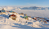
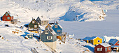
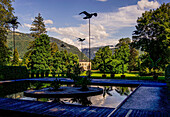
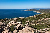
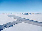
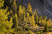
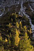
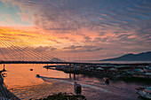
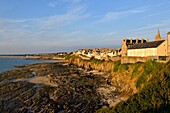
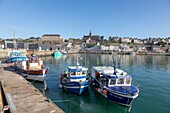
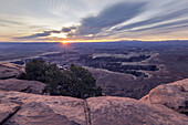
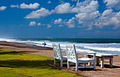
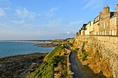
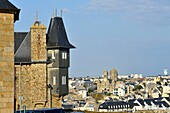
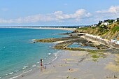
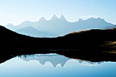
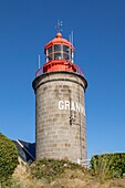
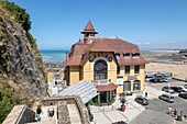
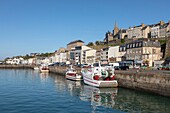
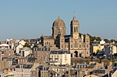
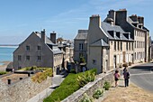
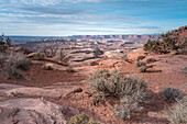
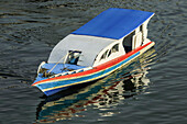
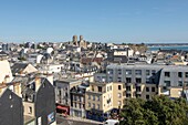
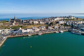
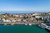
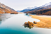
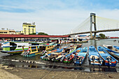
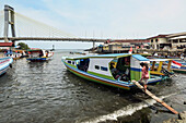
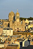
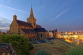
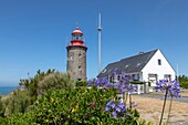
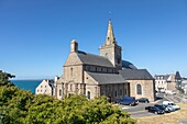
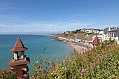
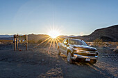
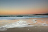
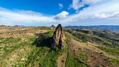
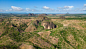
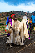
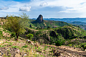
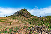
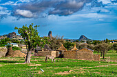
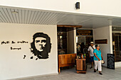
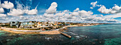
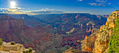
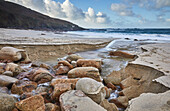
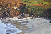
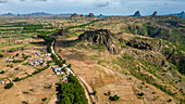
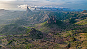
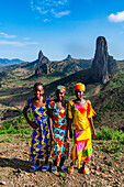
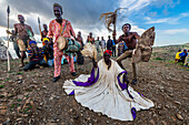
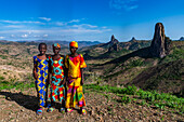
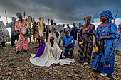
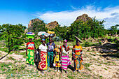
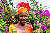
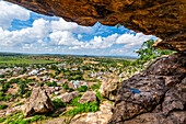
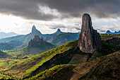
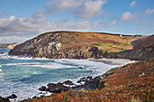
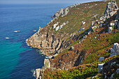
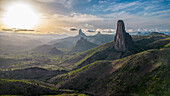
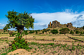
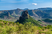
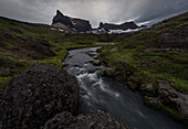
71422319 - The traditional and remote Greenlandic Inuit village Kullorsuaq located at the Melville Bay, in the far north of West Greenland, Danish territory71422318 - The traditional and remote Greenlandic Inuit village Kullorsuaq located at the Melville Bay, in the far north of West Greenland, Danish territory71409725 - Theme garden "... and yet so far away" in the Kaiserpark, Bad Ischl, Upper Austria, Austria14102220 - France, Corse du Sud, Monacia d'Aullene, the tip of Caniscione and the Genoese tower of Olmeto, far off the coast of Sardinia14100228 - France, Corse du Sud, Campomoro, Tizzano, hiking on the coastal path in the Senetosa reserve, from the top of the Genoese tower the view goes far to the sea and the west coast of the island71410996 - Sea ice with icebergs in the Baffin Bay, between Kullorsuaq and Upernavik in the far north of Greenland during winter.71388163 - Luminous autumnal mountain forest not far from the Drei Zinnen, South Tyrol, Italy, Europe71379980 - Luminous autumnal mountain forest not far from the Drei Zinnen, South Tyrol, Italy, Europe14142145 - Manado port and Soekarno Bridge with Manadotua Island beyond at sunset in provincial capital of Sulawesi's far north, Manado, North Sulawesi, Indonesia, Southeast Asia, Asia13979313 - France,Manche,Cotentin,Granville,the Upper Town built on a rocky headland on the far eastern point of the Mont Saint Michel Bay13973770 - France,Eure,Marais Vernier region,Natural Reserve of the Seine estuary,Saint Samson de la Roque,Roque lighthouse on Pointe de la Roque overlooks the Seine river estuary,the Normandy bridge far in the background (aerial view)13934086 - France, Manche, Cotentin, Granville, the Upper Town built on a rocky headland on the far eastern point of the Mont Saint Michel Bay, the fishing port and the Notre Dame du Cap Lihou\n13828911 - USA, Utah, Canyonlands National Park: sunrise on Grand View Point, icon of the Far West71375228 - Magnificent view not far from the Guglhör estate over the Murnauer Moos to the Wetterstein Mountains in October, Murnau, Bavaria, Germany71368085 - Lena rocks. The huge rocks (Stolby, German: Pfaehle) up to 100 m high stretch along the river bank of the Lena over a length of 80 km. Jakutsk, Lena, Lenafelsen, Stolby, Far East, Asia, Russia, Sacha, Yakutia,71356139 - Two, white deck chairs set along a beach with a surfer and his board in the far background.\nShot in Seminyak, Bali, Indonesia13978721 - France,Manche,Cotentin,Granville,the Upper Town built on a rocky headland on the far eastern point of the Mont Saint Michel Bay13977427 - France,Manche,Cotentin,Granville,the Upper Town built on a rocky headland on the far eastern point of the Mont Saint Michel Bay,in the background Saint Paul church13976232 - France,Manche,Cotentin,Granville,the Upper Town built on a rocky headland on the far eastern point of the Mont Saint Michel Bay,Plat Gousset beach and promenade13973293 - France,Savoie,Saint Jean de Maurienne,not far from the cross of the Iron Cross,sunrisel on the needles of Arves and Lake Guichard13937712 - France, Manche, Cotentin, Granville, the Upper Town built on a rocky headland on the far eastern point of the Mont Saint Michel Bay, the fishing port and the Notre Dame du Cap Lihou\n14142142 - Covered ferry boats in Manado port with Soekarno Bridge beyond in provincial capital of Sulawesi's far north, Manado, North Sulawesi, Indonesia, Southeast Asia, Asia13978491 - France,Manche,Cotentin,Granville,the Upper Town built on a rocky headland on the far eastern point of the Mont Saint Michel Bay,Plat Gousset beach and promenade,the casino towers in the foreground13972929 - France,Savoie,Saint Jean de Maurienne,not far from the cross of the Iron Cross,the needles of Arves and Lake Guichard13937412 - France, Manche, Cotentin, Granville, fortified town built on a rocky headland on the far eastern point of the Mont Saint Michel Bay, Granville lighthouse or Cap Lihoulighthouse at pointe du Roc\n13934489 - France, Manche, Cotentin, Granville, the Upper Town built on a rocky headland on the far eastern point of the Mont Saint Michel Bay, the casino\n13933657 - France, Manche, Cotentin, Granville, the Upper Town built on a rocky headland on the far eastern point of the Mont Saint Michel Bay, the fishing port and the Notre Dame du Cap Lihou\n13832507 - Crystal sea washing the white sand of Kedrodasos beach, not far from famous Elafonisi lagoon, southwest Chania, Crete, Greece13822660 - Switzerland, Canton of the Grisons, Maloja region, Sils im Engadin/Segl: Lake Sils in autumn, with Lake Silvaplana covered in mist far in the background.14142140 - Boats in Manado port and Soekarno Bridge in provincial capital of Sulawesi's far north, Manado, North Sulawesi, Indonesia, Southeast Asia, Asia13977965 - France,Manche,Cotentin,Granville,the Upper Town built on a rocky headland on the far eastern point of the Mont Saint Michel Bay13976450 - France,Manche,Cotentin,Granville,the Upper Town built on a rocky headland on the far eastern point of the Mont Saint Michel Bay,the upper city,rue Saint-Jean13976336 - France,Manche,Cotentin,Granville,the Upper Town built on a rocky headland on the far eastern point of the Mont Saint Michel Bay,lower town and Saint Paul church13975986 - France,Savoie,Saint Jean de Maurienne,not far from the cross of the Iron Cross,the needles of Arves and Lake Guichard13936447 - France, Savoie, Lake Bourget, Aix les Bains, Riviera of the Alps, the north coast very wild not far from Chatillon\n13934752 - France, Manche, Cotentin, Granville, the Upper Town built on a rocky headland on the far eastern point of the Mont Saint Michel Bay, fishing port and trawlers\n13934063 - France, Manche, Cotentin, Granville, the Upper Town built on a rocky headland on the far eastern point of the Mont Saint Michel Bay, place Cambernon in the upper town\n13933568 - France, Manche, Cotentin, Granville, the Upper Town built on a rocky headland on the far eastern point of the Mont Saint Michel Bay, lower town and Saint Paul church\n13929831 - France, Manche, Cotentin, Granville, the Upper Town built on a rocky headland on the far eastern point of the Mont Saint Michel Bay, upper town\n13828913 - USA, Utah, Canyonlands National Park: sunrise on Grand View Point, icon of the Far West14142141 - Typical colourful covered ferry boat in the port of provincial capital in Sulawesi's far north, Manado, North Sulawesi, Indonesia, Southeast Asia, Asia13979570 - France,Seine Maritime,Rouen,place de la Pucelle in honor of Joan of Arc burned alive not far from there13976827 - France,Manche,Cotentin,Granville,the Upper Town built on a rocky headland on the far eastern point of the Mont Saint Michel Bay13975695 - France,Savoie,Saint Jean de Maurienne,not far from the cross of the Iron Cross,the needles of Arves and Lake Guichard13975453 - /France,Manche,Cotentin,Granville,the Upper Town built on a rocky headland on the far eastern point of the Mont Saint Michel Bay,statue of Georges René Le Pelley de Pléville says the Corsair with a wooden leg,in the background Saint Paul church13974104 - France,Manche,Cotentin,Granville,the Upper Town built on a rocky headland on the far eastern point of the Mont Saint Michel Bay,the port13973100 - France,Manche,Cotentin,Granville,the Upper Town built on a rocky headland on the far eastern point of the Mont Saint Michel Bay,statue of Georges René Le Pelley de Pléville says the Corsair with a wooden leg13972924 - /France,Manche,Cotentin,Granville,the Upper Town built on a rocky headland on the far eastern point of the Mont Saint Michel Bay,statue of Georges René Le Pelley de Pléville says the Corsair with a wooden leg,in the background Saint Paul church13936284 - France, Manche, Cotentin, Granville, the Upper Town built on a rocky headland on the far eastern point of the Mont Saint Michel Bay, the port\n13933613 - France, Manche, Cotentin, Granville, the Upper Town built on a rocky headland on the far eastern point of the Mont Saint Michel Bay, lower town and Saint Paul church\n13932704 - France, Manche, Cotentin, Granville, the Upper Town built on a rocky headland on the far eastern point of the Mont Saint Michel Bay, the fishing port and the Notre Dame du Cap Lihou (aerial view)\n13930548 - France, Manche, Cotentin, Granville, the Upper Town built on a rocky headland on the far eastern point of the Mont Saint Michel Bay, the fishing port and the Notre Dame du Cap Lihou (aerial view)\n13822658 - Switzerland, Canton of the Grisons, Maloja region, Sils im Engadin/Segl: Lake Sils in autumn, with Lake Silvaplana covered in mist far in the background.14142144 - Typical ferry boats in Manado port with the Soekarno Bridge beyond in provincial capital of Sulawesi's far north, Manado, North Sulawesi, Indonesia, Southeast Asia, Asia14142143 - Covered ferry boats in Manado port with the Soekarno Bridge beyond in provincial capital of Sulawesi's far north, Manado, North Sulawesi, Indonesia, Southeast Asia, Asia13979513 - France,Manche,Cotentin,Granville,the Upper Town built on a rocky headland on the far eastern point of the Mont Saint Michel Bay,lower town and Saint Paul church13976353 - France,Manche,Cotentin,Granville,the Upper Town built on a rocky headland on the far eastern point of the Mont Saint Michel Bay,Notre Dame du Cap Lihou church in the upper city13975976 - France,Savoie,Saint Jean de Maurienne,not far from the cross of the Iron Cross,the needles of Arves and Lake Guichard13975296 - France,Eure,Marais Vernier region,Natural Reserve of the Seine estuary,Saint Samson de la Roque,Roque lighthouse on Pointe de la Roque overlooks the Seine river estuary,the Normandy bridge far in the background (aerial view)13973503 - France,Savoie,Saint Jean de Maurienne,not far from the cross of the Iron Cross,the needles of Arves and Lake Guichard13972855 - France,Savoie,Saint Jean de Maurienne,not far from the cross of the Iron Cross,panoramic view of the needles of Arves and Lake Guichard13972340 - France,Manche,Cotentin,Granville,the Upper Town built on a rocky headland on the far eastern point of the Mont Saint Michel Bay13971959 - France,Manche,Cotentin,Granville,the Upper Town built on a rocky headland on the far eastern point of the Mont Saint Michel Bay13936683 - France, Manche, Cotentin, Granville, the Upper Town built on a rocky headland on the far eastern point of the Mont Saint Michel Bay, place Cambernon in the upper town\n13935036 - France, Manche, Cotentin, Granville, the Upper Town built on a rocky headland on the far eastern point of the Mont Saint Michel Bay\n13933245 - France, Manche, Cotentin, Granville, fortified town built on a rocky headland on the far eastern point of the Mont Saint Michel Bay, Granville lighthouse or Cap Lihoulighthouse at pointe du Roc\n13932658 - France, Manche, Cotentin, Granville, the Upper Town built on a rocky headland on the far eastern point of the Mont Saint Michel Bay, Notre Dame du Cap Lihou church\n13932418 - France, Manche, Cotentin, Granville, the Upper Town built on a rocky headland on the far eastern point of the Mont Saint Michel Bay, Plat Gousset beach and promenade, the casino towers in the foreground\n13829145 - Chevrolet Silverado at Teakettle Junction, an iconic point in the far wilderness of the desert; North America, USA, California, Death Valley National Park13923470 - Atlantic shoreline at sunset, Whitesand Bay, Sennen Cove, near Land's End, in the far west of Cornwall, England, United Kingdom, Europe\n13922709 - Aerial of Rhumsiki peak in the lunar landscape of Rhumsiki, Mandara mountains, Far North province, Cameroon, Africa\n13922707 - Aerial of Rhumsiki peak in the lunar landscape of Rhumsiki, Mandara mountains, Far North province, Cameroon, Africa\n13922643 - Kapsiki tribal people practising a traditional dance, Rhumsiki, Mandara mountains, Far North province, Cameroon, Africa\n13922641 - Lunar landscape, Rhumsiki, Mandara mountains, Far North province, Cameroon, Africa\n13922639 - Lunar landscape, Rhumsiki, Mandara mountains, Far North province, Cameroon, Africa\n13922636 - Compound walls in lunar landscape, Rhumsiki, Mandara mountains, Far North province, Cameroon, Africa\n13817782 - Today's tourism is a far cry from Che Guevara's vision for Cuba, Varadero, Cuba, West Indies, Caribbean, Central America13815770 - Aerial drone panoramic view of promenade in Cascais, on the Portuguese Riveira 30km west of Lisbon, with Estoril visible on the far right, Cascais, Portugal, Europe13708900 - Grand Canyon viewed from the cliffs west of Moran Point with Coronado Butte on the far left, Grand Canyon National Park, UNESCO World Heritage Site, Arizona, United States of America, North America13923476 - A stream cuts through sand and rocks as it makes its final dash to the sea, Portheras Cove, a remote cove on the Atlantic Coast, near Pendeen, in the far west of Cornwall, England, United Kingdom, Europe\n13923463 - The cliffs and sands of Portheras Cove, a remote beach near Pendeen, on the rugged Atlantic cliffs of the far west of Cornwall, England, United Kingdom, Europe\n13922705 - Aerial of Rhumsiki peak in the lunar landscape of Rhumsiki, Mandara mountains, Far North province, Cameroon, Africa\n13922704 - Aerial of Rhumsiki peak in the lunar landscape of Rhumsiki, Mandara mountains, Far North province, Cameroon, Africa\n13922658 - Three Kapsiki tribal girls in front of the lunar landscape of Rhumsiki , Rhumsiki, Mandara mountains, Far North province, Cameroon, Africa\n13922656 - Kapsiki tribal people practising a traditional dance, Rhumsiki, Mandara mountains, Far North province, Cameroon, Africa\n13922654 - Three Kapsiki tribal girls in front of the lunar landscape, Rhumsiki, Mandara mountains, Far North province, Cameroon, Africa\n13922652 - Kapsiki tribal people practising a traditional dance, Rhumsiki, Mandara mountains, Far North province, Cameroon, Africa\n13922648 - Kapsiki women coming back from the fields, Rhumsiki, Mandara mountains, Far North province, Cameroon, Africa\n13922642 - Friendly Kapsiki tribal girl, Rhumsiki, Mandara mountains, Far North province, Cameroon, Africa\n13922638 - View over the village of Rhumsiki from a cave, Mandara mountains, Far North province, Cameroon, Africa\n13922633 - Rhumsiki peak in the lunar landscape of Rhumsiki, Mandara mountains, Far North province, Cameroon, Africa\n13901081 - Aerial drone panoramic view of Sintra National Park, with Cabo da Roca in the far left background, next to Guincho Beach, Cascais, Portugal, Europe13923480 - The cliffs and sands of Portheras Cove, a remote beach near Pendeen, on the rugged Atlantic cliffs of the far west of Cornwall, England, United Kingdom, Europe\n13923475 - The wild and rugged granite cliffs of Cornwall's Atlantic coast seen in summer, near Pendeen, in the far west of Cornwall, England, United Kingdom, Europe\n13922710 - Aerial of Rhumsiki peak in the lunar landscape of Rhumsiki, Mandara mountains, Far North province, Cameroon, Africa\n13922703 - Aerial of Rhumsiki peak in the lunar landscape of Rhumsiki, Mandara mountains, Far North province, Cameroon, Africa\n13922637 - Fields and lunar landscape, Rhumsiki, Mandara mountains, Far North province, Cameroon, Africa\n13922634 - Lunar landscape, Rhumsiki, Mandara mountains, Far North province, Cameroon, Africa\n13817587 - Dyrfjoll mountain range in far east of Iceland, Polar Regionsnext page