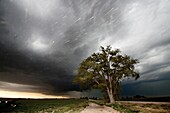
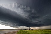
70859691 - Tornadic supercell just east of Kearney, Nebraska, May 29, 2008 Shot from exit of interstate 8071103379 - Very intense high precipitation supercell storm moves south in the Nebraska Sand Hills south of Valentine, July 13, 2009. Very low, long and fat inflow cloud stretches east of the storm. Winds gusted upwards of 60+ mph into this storm. Tornado warning wit71103369 - Supercell storm moves north of McCook Nebraska as a UPS driver zooms through falling hail stones.71103368 - Supercell producing large hail moves over Meno Oklahoma.71103358 - Striated supercell passes just north of Grand Island Nebraska May 10, 2005 producing large hail and lightning during twilight.71103349 - Sun shines under long-lived supercell moving across northeast Nebraska May 28, 2004, almost following highway 12 from Niobrara down to Sioux City perfectly.71103348 - Long-lived supercell moves across northeast Nebraska May 28, 2004, allmost following highway 12 from Niobrara down to Sioux City perfectly.70649106 - A lone tree stands against a thunderstorm on the rural Nebraska prairie near Scottsbluff, Nebraska, USA, June 7, 201070343916 - An old-fashioned windmill set against the roiling clouds of a severe thunderstorm in northern Oklahoma, May 12, 201070343901 - A supercellular thunderstorm near Dodge City, Kansas, USA, June 9, 200971103382 - Tornado from a tornadic supercell approaches from the south, west of York Nebraska June 20, 2011.71103381 - Tornado forms under long-lived supercell in northern Kansas, May 24, 2004. This supercell produced upwards of 15 tornadoes in just a few hours. It frequently had more than one tornado on the ground at the same time.71103376 - Very fast moving and severe bow echo moves down the highway from Redfield to Watertown South Dakota. Forward speed of the bow was around 60mph. At least 80mph winds accompanied the bow in areas, with many trees uprooted, poles snapped, gran bins destroyed71103371 - Supercell moves across the country near West Point Nebraska.71103370 - Severe supercell storm drops southeast in northern Kansas as the setting sun shines underneath.71103367 - Supercell storm that produced the world record hail stone in Vivian SD, July 23, 2010, now reorganizing east of Vivian. The stone measured 8 inches in diameter!.71103361 - Supercell storm moves across the badlands area of southwest South Dakota near Kadoka, June 7, 2005.71103354 - Slow moving tornadic supercell speeds up and gusts out as a fast moving shelf cloud July 12, 2004 near Bartlett Nebraska.71103352 - Supercell storm moves near Alvo Nebraska June 13, 2004. The storm produced a tornado near Waverly and a couple more small tornadoes near Alvo.71103351 - Long-lived supercell moves across northeast Nebraska May 28, 2004, allmost following highway 12 from Niobrara down to Sioux City perfectly. People in South Sioux City seemed a little frightened by the sight.70343915 - A dirt road leads into the arcus cloud of a severe thunderstorm in northern Oklahoma, May 12, 201071103378 - Amazing supercell storm during twilight nears a York Nebraska truck stop on I80 as it spits out lightning, June 17, 2009. Only a half hour or so earlier this storm was producing a long-lived large tornado near Aurora Nebraska.71103374 - Severe storm races southeast in southwest Nebraska June 10, 2006 producing high winds and small hail.71103372 - A grungy supercell moves across northwest Missouri.71103360 - Supercell storm with small tornado moves across the badlands area of southwest South Dakota near Kadoka, June 7, 2005.71103357 - Amazing supercell passes just north of Grand Island Nebraska May 10, 2005.71103346 - Long-lived supercell moves across northeast Nebraska May 28, 2004, allmost following highway 12 from Niobrara down to Sioux City perfectly.70343896 - Tornadic supercell just east of Kearney, Nebraska, May 29, 2008 Shot from exit of interstate 8071103398 - Lightning strikes western Iowa north of Omaha Nebraska during twilight. City lights and a power plant´s lights create a red-orange color to the rain during a longer exposure. Moon light helps light up the puffy clouds.71103383 - Tornado from a tornadic supercell approaches from the south, west of York Nebraska June 20, 2011.71103377 - Very fast moving and severe bow echo moves down the highway from Redfield to Watertown South Dakota. Forward speed of the bow was around 60mph. At least 80mph winds accompanied the bow in areas, with many trees uprooted, poles snapped, gran bins destroyed71103350 - Long-lived supercell moves across northeast Nebraska May 28, 2004, allmost following highway 12 from Niobrara down to Sioux City perfectly. People in South Sioux City seemed a little frightened by the sight.71103347 - Long-lived supercell moves across northeast Nebraska May 28, 2004, allmost following highway 12 from Niobrara down to Sioux City perfectly.71103389 - Lightning rises from tv towers in north Omaha.71103380 - Supercell storm that produced the world record hail stone in Vivian SD, July 23, 2010, now reorganizing east of Vivian. The stone measured 8 inches in diameter!.71103373 - Supercell produces hail up to 3.5 inches in diameter near Lake Andes South Dakota as it heads south into north Nebraska.71103366 - Very intense high precipitation supercell storm moves south in the Nebraska Sand Hills south of Valentine, July 13, 2009. Winds gusted upwards of 60 mph into this storm. Tornado warning with the storm mentioned baseball size hail and winds in excess of 1071103364 - Instense supercell storm moves south near Mission South Dakota, July 13, 2009.71103363 - High precipitation supercell storm tracks south of Hastings Nebraska June 15, 2009 as irrigation pivot waters the field ahead of the storm.71103359 - Supercell storm moves across eastern Colorado June 2, 2005.71103353 - Supercell storm moves near Alvo Nebraska June 13, 2004. The storm produced a tornado near Waverly and a couple more small tornadoes near Alvo.70343904 - View of a severe thunderstorm in Kansas, 6/10/2009 Shot during Project Vortex 2, a two year science mission to study tornadoes71103375 - Supercell storm passes near the town of Colfax North Dakota August 5, 2006.71103365 - Very intense high precipitation supercell storm moves south in the Nebraska Sand Hills south of Valentine, July 13, 2009. Winds gusted upwards of 60 mph into this storm. Tornado warning with the storm mentioned baseball size hail and winds in excess of 1071103362 - Supercell storm passes near the town of Colfax North Dakota August 5, 2006.71103356 - Wall cloud hangs over the southwest Iowa landscape August 26, 2004.71103355 - Slow moving tornadic supercell speeds up and gusts out as a fast moving shelf cloud July 12, 2004 near Bartlett Nebraska.70244002 - Halloween mask - pumpkin mask