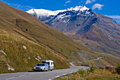
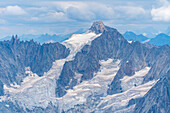
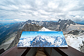
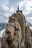
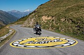
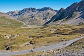
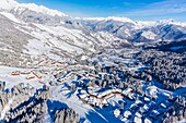
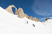
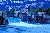
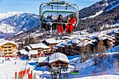
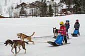
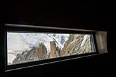
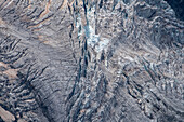
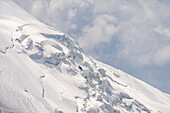
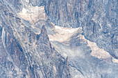
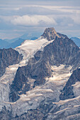
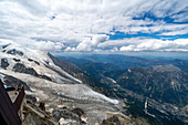
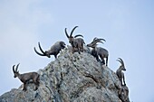
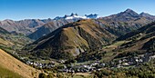
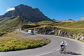
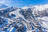
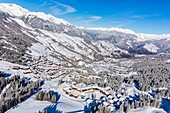
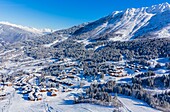
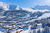
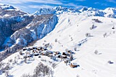
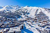
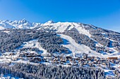
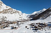
13880657 - Europe, France, Savoie, Road Through Pass Of Mont Cenis71416611 - View from the Aiguille du Midi of the Bessons Glacier and Mont Blanc, Vallée de Chamonix-Mont-Blanc, Le Mont-Blanc, Bonneville, Haute-Savoie, Auvergne-Rhône-Alpes, France71416595 - View from the Aiguille du Midi on a rope team in the high mountains, Vallée de Chamonix-Mont-Blanc, Le Mont-Blanc, Bonneville, Haute-Savoie, Auvergne-Rhône-Alpes, France71416590 - Climbers coming from Mont Blanc on a groomed path, Vallée de Chamonix-Mont-Blanc, Le Mont-Blanc, Bonneville, Haute-Savoie, Auvergne-Rhône-Alpes, France71416588 - Details from the glacier on Mont Blanc, Vallée de Chamonix-Mont-Blanc, Le Mont-Blanc, Bonneville, Haute-Savoie, Auvergne-Rhône-Alpes, France71416578 - View from the Aiguille du Midi to the Aiguilli de Triolet, Vallée de Chamonix-Mont-Blanc, Le Mont-Blanc, Bonneville, Haute-Savoie, Auvergne-Rhône-Alpes, France71416568 - View from the Aiguille du Midi to the Aiguilli deTriolet, Vallée de Chamonix-Mont-Blanc, Le Mont-Blanc, Bonneville, Haute-Savoie, Auvergne-Rhône-Alpes, France71416562 - View from the Aiguille du Midi with panorama table from Talèfer Glacier and Jardin, Vallée de Chamonix-Mont-Blanc, Le Mont-Blanc, Bonneville, Haute-Savoie, Auvergne-Rhône-Alpes, France71416559 - View of Aiguille du Midi with transmission towers, Vallée de Chamonix-Mont-Blanc, Le Mont-Blanc, Bonneville, Haute-Savoie, Auvergne-Rhône-Alpes, France14199729 - France, Savoie, Saint Jean de Maurienne, Saint Colomban des Villards, the largest cycling area in the world was created within a radius of 50 km around the city, Glandon pass, a magnificent painting on the asphalte encourages a German cyclist14199727 - France, Savoie, Saint Jean de Maurienne, Saint Sorlin d'Arves, Pass of the Iron Cross, the needles of Arves14199725 - France, Savoie, Saint Jean de Maurienne, the largest bike trail in the world was created within a radius of 50 km around the city. under the Iron Cross Pass, view of cyclists and Lake Laitelet and the needles of Arves14199722 - France, Savoie, Saint Jean de Maurienne, not far from the cross of the Iron Cross, the needles of Arves and Lake Guichard14199716 - France, Savoie, Saint Jean de Maurienne, not far from the cross of the Iron Cross, sunrisel on the needles of Arves and Lake Guichard14199709 - France, Savoie, Saint Jean de Maurienne, the largest cycling area in the world was created within a radius of 50 km around the city. Pass of the Iron Cross, descent of cyclists to the village of Saint Sorlin d'Arves14199700 - France, Savoie, Massif des Cerces, Valloire, cycling climb of the Col du Galibier, one of the routes of the largest cycling area in the world, last kilometer before the summit and rock of the great Pare14199695 - France, Savoie, Valloire, massif des Cerces, cycling ascension of the Col du Galibier, one of the routes of the largest cycle area in the world, view of the rock Termier effect of clouds at sunset14199688 - France, Savoie, massif des Cerces, Valloire, cycling ascension of the Col du Galibier, one of the routes of the largest cycling area in the world, field of flowers of epilobes and rock of the great Pare seen from the hamlet of Granges14199687 - France, Savoie, Massif des Cerces, Valloire, cycling climb of the Col du Galibier, one of the routes of the largest cycling area in the world, last kilometer before the summit and rock of the great Pare14197278 - France, Savoie, before Savoyard country, Lake Aiguebelette panoramic view of the two islands of the lake14197269 - France, Savoie, Lake Aiguebelette, the lake house in Nances14196300 - France, Savoie, Vanoise massif, valley of Haute Tarentaise, La Plagne, part of the Paradiski area, view of Belle Plagne, (aerial view)14195311 - France, Savoie, Valmorel, Massif of the Vanoise, Tarentaise valley, view of the massif of La Lauziere and the massif of Beaufortain, (aerial view)14195164 - France, Savoie, Vanoise Massif, Val d'Isere, daille gondola lift, La Folie Douce ambiance bar14195148 - France, Savoie, Vanoise Massif, aiguille Percee (2748m)14194914 - France, Savoie, Champagneux, dam factory of Champagneux on the Rhone14194652 - France, Savoie, Valmorel, Tarentaise valley, massif of the Vanoise, view of the the chairlift the Altispace14194645 - France, Savoie, Valmorel, Massif of the Vanoise, Tarentaise valley, the street Du Bourg with a view of the Cheval Noir (2832m)14194640 - France, Savoie, Valmorel, Massif of the Vanoise, Tarentaise valley14194627 - France, Savoie, Vanoise massif, valley of Haute Tarentaise, Les Arcs 2000, part of the Paradiski area, view of the Club MED (aerial view)14194622 - France, Savoie, Vanoise massif, valley of Haute Tarentaise, Les Arcs 2000, part of the Paradiski area, view of the Mont Blanc (4810m) and La Rosiere resort (aerial view)14194615 - France, Savoie, Tarentaise valley, La Tania is one of the largest skiresort village in France, in the heart of Les Trois Vallees (The Three Valleys), one of the biggest ski areas in the world with 600km of marked trails, western part of the Vanoise Massif (aerial view)14194389 - France, savoie, Tarentaise valley, Tignes ski resort, altitude restaurant le Panoramic (3032m), Bouvier family14194386 - France, savoie, Tarentaise valley, Tignes ski resort, altitude restaurant le Panoramic (3032m), Bouvier family14194385 - France, savoie, Tarentaise valley, Tignes ski resort, altitude restaurant le Panoramic (3032m), Bouvier family14194379 - France, savoie, Tarentaise valley, Tignes ski resort, altitude restaurant le Panoramic (3032m), Bouvier family14194376 - France, savoie, Tarentaise valley, Tignes ski resort, altitude restaurant le Panoramic (3032m), Bouvier family14194375 - France, savoie, Tarentaise valley, Tignes ski resort, altitude restaurant le Panoramic (3032m), Bouvier family14102530 - France, Savoie, ski area of the 3 valleys, Saint Martin de Belleville, resort of Menuires the hamlet of Fontanettes14102071 - France, Savoie, ski area of the 3 valleys, Saint Martin de Belleville, chapel our lady of life restored in 201514097771 - France, Savoie, Chambery, in the old town, ray of sunshine under the covered footbridge of the low street of the castle14097585 - France, Haute Savoie, Annecy, the churches of Saint Francis de Sales and Saint Maurice and the quai du Semnoz on the banks of the Thiou canal spillway of the lake14097402 - France, Savoie, Massif de la Vanoise, Pralognan La Vanoise, National Park, towards the Bochor, orientation table on the ski area and the Bochor needle14096945 - France, Savoie, Massif de la Vanoise, Pralognan La Vanoise, National Park, panoramic view the village at dawn and the Grand Marchet mountain, and teeth of Portetta,14096306 - France, Savoie, Massif de la Vanoise, Pralognan La Vanoise, National Park, snow grooming to night on the slopes of the Gliere valley14096163 - France, Haute Savoie, massive Bauges, above Annecy limit with the Savoie, the Semnoz plateau exceptional belvedere on the Northern Alps, cross country skiing trails south of the plateau14096148 - France, Savoie, Massif de la Vanoise, Pralognan La Vanoise, National Park, introductory activity for dogsledding for young children14095914 - France, Haute Savoie, massive Bauges, above Annecy in border with the Savoie, the Semnoz plateau exceptional belvedere on the Northern Alps, cross country ski trails south of the plateau and sea of clouds14095819 - France, Savoie, Vanoise massif, valley of Haute Tarentaise, Les Arcs 2000, part of the Paradiski area, view of the Mont Blanc (4810m)14095617 - France, Savoie, ski area of the 3 valleys, Saint Martin de Belleville, resort of Menuires, hamlet and of Reberty 185014095532 - France, Savoie, Les Marches, Lake Saint André in the heart of the Combe de Savoie vineyards, Belledonne range covered with snow in the background14095520 - France, Savoie, Les Marches, Lake Saint André in the heart of the Combe de Savoie vineyards, Belledonne range covered with snow in the background14095492 - France, Haute Savoie, massive Bauges, above Annecy limit with the Savoie, the Semnoz plateau exceptional belvedere on the Northern Alps, cross skating skier and snow covered fir trees14094629 - France, Haute Savoie, massive Bauges, above Annecy limit with the Savoie, the Semnoz plateau exceptional belvedere on the Northern Alps, panoramic view of the snow laden forest and massive Bornes and Mount White14094615 - France, Haute Savoie, massive Bauges, above Annecy limit with the Savoie, the Semnoz plateau exceptional belvedere on the Northern Alps, sunrise on snow sculpted by the wind and massive Bornes and of Mont Blanc14094384 - France, Savoie, Vanoise massif, valley of Haute Tarentaise, Les Arcs 2000, part of the Paradiski area, view of the Mont Blanc (4810m)14094348 - France, Haute Savoie, massive Bauges, above Annecy in border with the Savoie, the Semnoz plateau exceptional belvedere on the Northern Alps, cross country ski trails south of the plateau and sea of clouds14094224 - France, Haute Savoie, massive Bauges, above Annecy limit with the Savoie, on the plateau Semnoz snow stuck on a facade of chalet14094035 - France, Savoie, ski area of the 3 valleys, Saint Martin de Belleville, resort of Menuires, hamlet of Reberty village14093992 - France, Savoie, Massif de la Vanoise, Pralognan La Vanoise, National Park, at the top of the slopes of the gliere valley, the Balmettes refuge14093914 - France, Savoie, Massif de la Vanoise, Pralognan La Vanoise, National Park, on the ski area, group of skiers with instructor on the blue slope of the Combe14093892 - France, Haute Savoie, massive Bauges, above Annecy limit with the Savoie, the Semnoz plateau exceptional belvedere on the Northern Alps, fir trees loaded with snow14093760 - France, Savoie, Massif de la Vanoise, Pralognan La Vanoise, National Park, on the ski area, the chairlift of Ancolies and the teeth of Portetta14093454 - France, Haute Savoie, massive Bauges, above Annecy limit with the Savoie, the Semnoz plateau exceptional belvedere on the Northern Alps, cross skating skier and snow covered fir trees71416607 - View of the walkable steel tube at the Aiguille du Midi mountain station, Vallée de Chamonix-Mont-Blanc, Le Mont-Blanc, Bonneville, Haute-Savoie, Auvergne-Rhône-Alpes, France71416606 - View from the walkable steel tube at the Aiguille du Midi mountain station, Vallée de Chamonix-Mont-Blanc, Le Mont-Blanc, Bonneville, Haute-Savoie, Auvergne-Rhône-Alpes, France71416587 - Details from the glacier on Mont Blanc, Vallée de Chamonix-Mont-Blanc, Le Mont-Blanc, Bonneville, Haute-Savoie, Auvergne-Rhône-Alpes, France71416583 - Details from the glacier on Mont Blanc, Vallée de Chamonix-Mont-Blanc, Le Mont-Blanc, Bonneville, Haute-Savoie, Auvergne-Rhône-Alpes, France71416581 - Details from the glacier on Mont Blanc, Vallée de Chamonix-Mont-Blanc, Le Mont-Blanc, Bonneville, Haute-Savoie, Auvergne-Rhône-Alpes, France71416571 - Rope team in the high mountains, Vallée de Chamonix-Mont-Blanc, Le Mont-Blanc, Bonneville, Haute-Savoie, Auvergne-Rhône-Alpes, France71416566 - View from the Aiguille du Midi of the Aiguilles Ravanell and Mummery, Vallée de Chamonix-Mont-Blanc, Le Mont-Blanc, Bonneville, Haute-Savoie, Auvergne-Rhône-Alpes, France71416565 - View from the Aiguille du Midi to the Aiguilli de Triolet, Vallée de Chamonix-Mont-Blanc, Le Mont-Blanc, Bonneville, Haute-Savoie, Auvergne-Rhône-Alpes, France71416561 - View from Aiguille du Midi over the glacier tongue of the Bessons Glacier to the Vallée de Chamonix-Mont-Blanc, Le Mont-Blanc, Bonneville, Haute-Savoie, Auvergne-Rhône-Alpes, France14202066 - France, Savoie, Beaufortain massif, alpine wildlife, group of old male ibexes to the Presset refuge14199738 - France, Savoie, Saint Jean de Maurienne, the largest cycling area in the world was created within a radius of 50 km around the city. At the cross of the Iron Cross (2067 m) panoramic view of Saint Sorlin d'Arves and the needles of Arves14199735 - France, Savoie, Saint Jean de Maurienne, the largest bike trail in the world was created within a radius of 50 km around the city. under the Iron Cross Pass, panoramic view of Lake Laitelet and the needles of Arves14199732 - France, Savoie, Saint Jean de Maurienne, the largest cycling area in the world was created within a radius of 50 km around the city. Pass of the Iron Cross, panoramique views of the sunset on the needles of Arves14199731 - France, Savoie, Saint Jean de Maurienne, the largest bike trail in the world was created within a radius of 50 km around the city, the Glandon Pass seen from the pass of the Iron Cross and the needles of the Argentière14199713 - France, Savoie, Saint Jean de Maurienne, the largest cycling area in the world was created within a radius of 50 km around the city. At the cross of the Iron Cross, Lake Guichard located a few hundred meters from the pass14199701 - France, Savoie, Valloire, massif des Cerces, cycling ascension of the Col du Galibier, one of the routes of the largest bike domain in the world, sunset on the Grand Galibier14199692 - France, Savoie, Massif des Cerces, Valloire, cycling ascension of the Col du Galibier, one of the routes of the largest cycling area in the world, a very small cyclist in this grandiose and mineral panorama of the Cerces mountains14199690 - France, Savoie, Massif des Cerces, Valloire, cycling ascension of the Col du Galibier, one of the routes of the largest cycling area in the world, an itinerant cyclist apprecie the grandiose landscape of the steep reliefs of the massif des Cerces14199689 - France, Savoie, Valloire, massif des Cerces, cycling ascension of the Col du Galibier, one of the routes of the largest bike domain in the world, a winding road with beautiful curves, the laces above Plan Lachat14199682 - France, Savoie, Valloire, massif des Cerces, cycling ascension of the Col du Galibier, one of the routes of the largest bike domain in the world, camper and cyclists share the road in front of the Grand Galibier14197280 - France, Savoie, Lake Aiguebelette, panoramic view of the lake and Saint Alban de Montbel and the mountain of the Epine14197279 - France, Savoie, Lake Aiguebelette, panoramic view of the lake with the large island and the mountain of Epine14197275 - France, Savoie, before Savoyard country, the vineyard of Jongieux and the mountain of Charvaz14197271 - France, Savoie, before Savoyard country, the vineyards and the village of Jongieux14197270 - France, Savoie, before Savoyard country, cyclists in balcony in the vineyards of Jongieux and the village14197264 - France, Savoie, Lake Aiguebelette, the fishing port with exclusively electric boats14196299 - France, Savoie, Vanoise massif, valley of Haute Tarentaise, La Plagne, part of the Paradiski area, view of Plagne Bellecote and Belle Plagne, (aerial view)14195324 - France, Savoie, Valmorel, Massif of the Vanoise, Tarentaise valley, view of the massif of La Lauziere and the Grand pic de la Lauziere (2829m), (aerial view)14195321 - France, Savoie, Valmorel, Massif of the Vanoise, Tarentaise valley, view of the massif of La Lauziere and the massif of Beaufortain, (aerial view)14195319 - France, Savoie, Valmorel, Massif of the Vanoise, Tarentaise valley, view of Creve Tete (2342m), (aerial view)14195316 - France, Savoie, Valmorel, Massif of the Vanoise, Tarentaise valley, view of the Pointe Du Grand Nielard (2544m), (aerial view)14195315 - France, Savoie, the village of Quarante Planes, Massif of the Vanoise, Tarentaise valley, view of the massif of La Lauziere and the Grand Pic de la Lauziere (2829m), (aerial view)14195303 - France, Savoie, Courchevel, Massif of the Vanoise, Tarentaise valley, view of the Sommet de La Saulire (2738m) (aerial view)14195299 - France, Savoie, Courchevel Village and Courchevel, Massif of the Vanoise, Tarentaise valley, view of the Sommet de La Saulire (2738m) (aerial view)14195163 - France, Savoie, Val d'Isere, Haute-Tarentaise, massif of the Vanoisenext page