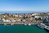
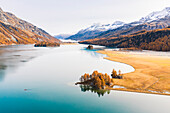
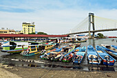
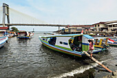
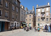
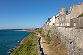
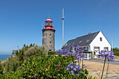
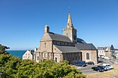
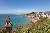
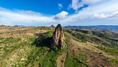
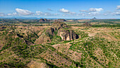
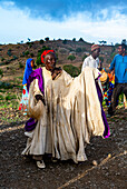
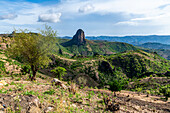
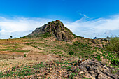
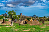
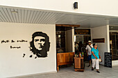
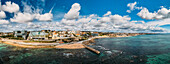
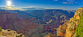
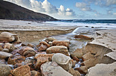
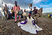
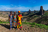
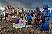
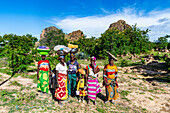
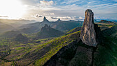
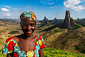
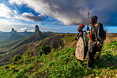
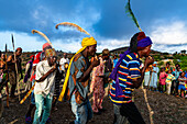
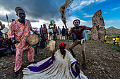
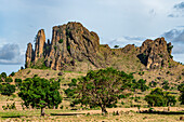
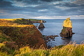
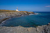
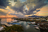
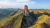
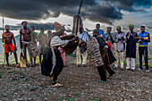
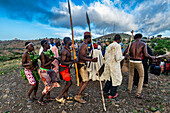
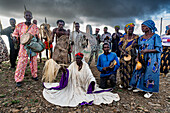
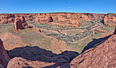
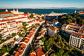
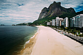
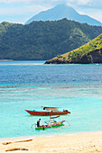
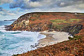
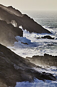
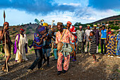
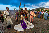
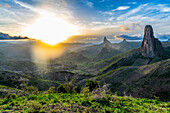
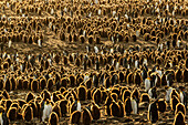
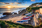
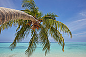
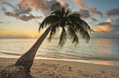
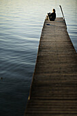
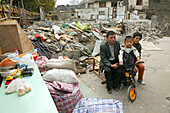
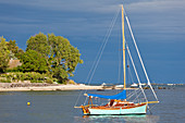
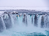
13930548 - France, Manche, Cotentin, Granville, the Upper Town built on a rocky headland on the far eastern point of the Mont Saint Michel Bay, the fishing port and the Notre Dame du Cap Lihou (aerial view)\n13822658 - Switzerland, Canton of the Grisons, Maloja region, Sils im Engadin/Segl: Lake Sils in autumn, with Lake Silvaplana covered in mist far in the background.14142144 - Typical ferry boats in Manado port with the Soekarno Bridge beyond in provincial capital of Sulawesi's far north, Manado, North Sulawesi, Indonesia, Southeast Asia, Asia14142143 - Covered ferry boats in Manado port with the Soekarno Bridge beyond in provincial capital of Sulawesi's far north, Manado, North Sulawesi, Indonesia, Southeast Asia, Asia13936683 - France, Manche, Cotentin, Granville, the Upper Town built on a rocky headland on the far eastern point of the Mont Saint Michel Bay, place Cambernon in the upper town\n13935036 - France, Manche, Cotentin, Granville, the Upper Town built on a rocky headland on the far eastern point of the Mont Saint Michel Bay\n13933245 - France, Manche, Cotentin, Granville, fortified town built on a rocky headland on the far eastern point of the Mont Saint Michel Bay, Granville lighthouse or Cap Lihoulighthouse at pointe du Roc\n13932658 - France, Manche, Cotentin, Granville, the Upper Town built on a rocky headland on the far eastern point of the Mont Saint Michel Bay, Notre Dame du Cap Lihou church\n13932418 - France, Manche, Cotentin, Granville, the Upper Town built on a rocky headland on the far eastern point of the Mont Saint Michel Bay, Plat Gousset beach and promenade, the casino towers in the foreground\n13829145 - Chevrolet Silverado at Teakettle Junction, an iconic point in the far wilderness of the desert; North America, USA, California, Death Valley National Park13923470 - Atlantic shoreline at sunset, Whitesand Bay, Sennen Cove, near Land's End, in the far west of Cornwall, England, United Kingdom, Europe\n13922709 - Aerial of Rhumsiki peak in the lunar landscape of Rhumsiki, Mandara mountains, Far North province, Cameroon, Africa\n13922707 - Aerial of Rhumsiki peak in the lunar landscape of Rhumsiki, Mandara mountains, Far North province, Cameroon, Africa\n13922643 - Kapsiki tribal people practising a traditional dance, Rhumsiki, Mandara mountains, Far North province, Cameroon, Africa\n13922641 - Lunar landscape, Rhumsiki, Mandara mountains, Far North province, Cameroon, Africa\n13922639 - Lunar landscape, Rhumsiki, Mandara mountains, Far North province, Cameroon, Africa\n13922636 - Compound walls in lunar landscape, Rhumsiki, Mandara mountains, Far North province, Cameroon, Africa\n13817782 - Today's tourism is a far cry from Che Guevara's vision for Cuba, Varadero, Cuba, West Indies, Caribbean, Central America13815770 - Aerial drone panoramic view of promenade in Cascais, on the Portuguese Riveira 30km west of Lisbon, with Estoril visible on the far right, Cascais, Portugal, Europe13708900 - Grand Canyon viewed from the cliffs west of Moran Point with Coronado Butte on the far left, Grand Canyon National Park, UNESCO World Heritage Site, Arizona, United States of America, North America13923476 - A stream cuts through sand and rocks as it makes its final dash to the sea, Portheras Cove, a remote cove on the Atlantic Coast, near Pendeen, in the far west of Cornwall, England, United Kingdom, Europe\n13923463 - The cliffs and sands of Portheras Cove, a remote beach near Pendeen, on the rugged Atlantic cliffs of the far west of Cornwall, England, United Kingdom, Europe\n13922705 - Aerial of Rhumsiki peak in the lunar landscape of Rhumsiki, Mandara mountains, Far North province, Cameroon, Africa\n13922704 - Aerial of Rhumsiki peak in the lunar landscape of Rhumsiki, Mandara mountains, Far North province, Cameroon, Africa\n13922658 - Three Kapsiki tribal girls in front of the lunar landscape of Rhumsiki , Rhumsiki, Mandara mountains, Far North province, Cameroon, Africa\n13922656 - Kapsiki tribal people practising a traditional dance, Rhumsiki, Mandara mountains, Far North province, Cameroon, Africa\n13922654 - Three Kapsiki tribal girls in front of the lunar landscape, Rhumsiki, Mandara mountains, Far North province, Cameroon, Africa\n13922652 - Kapsiki tribal people practising a traditional dance, Rhumsiki, Mandara mountains, Far North province, Cameroon, Africa\n13922648 - Kapsiki women coming back from the fields, Rhumsiki, Mandara mountains, Far North province, Cameroon, Africa\n13922642 - Friendly Kapsiki tribal girl, Rhumsiki, Mandara mountains, Far North province, Cameroon, Africa\n13922638 - View over the village of Rhumsiki from a cave, Mandara mountains, Far North province, Cameroon, Africa\n13922633 - Rhumsiki peak in the lunar landscape of Rhumsiki, Mandara mountains, Far North province, Cameroon, Africa\n13901081 - Aerial drone panoramic view of Sintra National Park, with Cabo da Roca in the far left background, next to Guincho Beach, Cascais, Portugal, Europe13923480 - The cliffs and sands of Portheras Cove, a remote beach near Pendeen, on the rugged Atlantic cliffs of the far west of Cornwall, England, United Kingdom, Europe\n13923475 - The wild and rugged granite cliffs of Cornwall's Atlantic coast seen in summer, near Pendeen, in the far west of Cornwall, England, United Kingdom, Europe\n13922710 - Aerial of Rhumsiki peak in the lunar landscape of Rhumsiki, Mandara mountains, Far North province, Cameroon, Africa\n13922703 - Aerial of Rhumsiki peak in the lunar landscape of Rhumsiki, Mandara mountains, Far North province, Cameroon, Africa\n13922637 - Fields and lunar landscape, Rhumsiki, Mandara mountains, Far North province, Cameroon, Africa\n13922634 - Lunar landscape, Rhumsiki, Mandara mountains, Far North province, Cameroon, Africa\n13817587 - Dyrfjoll mountain range in far east of Iceland, Polar Regions13923473 - The cliffs and sands of Portheras Cove, a remote beach near Pendeen, on the rugged Atlantic cliffs of the far west of Cornwall, England, United Kingdom, Europe\n13923447 - Granite boulders strewn across the shore at Porth Nanven, at the end of Cot Valley, near St. Just, Atlantic coast of the far west of Cornwall, England, United Kingdom, Europe\n13923140 - View of Grand Canyon from Bright Angel Point on the North Rim, with Brahma and Zoroaster Temples visible in the distance an Oza Butte on far right, Grand Canyon National Park, UNESCO World Heritage Site, Arizona, United States of America, North America\n13922711 - Aerial of Rhumsiki peak in the lunar landscape of Rhumsiki, Mandara mountains, Far North province, Cameroon, Africa\n13922708 - Aerial of Rhumsiki peak in the lunar landscape of Rhumsiki, Mandara mountains, Far North province, Cameroon, Africa\n13922702 - Aerial of Rhumsiki peak in the lunar landscape of Rhumsiki, Mandara mountains, Far North province, Cameroon, Africa\n13922701 - Aerial of Rhumsiki peak in the lunar landscape of Rhumsiki, Mandara mountains, Far North province, Cameroon, Africa\n13922659 - Kapsiki tribal girl in front of the lunar landscape of Rhumsiki , Rhumsiki, Mandara mountains, Far North province, Cameroon, Africa\n13922657 - Kapsiki tribal men in front of the lunar landscape of Rhumsiki peak, Rhumsiki, Mandara mountains, Far North province, Cameroon, Africa\n13922650 - Kapsiki tribal people practising a traditional dance, Rhumsiki, Mandara mountains, Far North province, Cameroon, Africa\n13922645 - Kapsiki tribal people practising a traditional dance, Rhumsiki, Mandara mountains, Far North province, Cameroon, Africa\n13922632 - Lunar landscape, Rhumsiki, Mandara mountains, Far North province, Cameroon, Africa\n13818185 - Gorgeous evening sunlight at Duncansby Head in autumn, in Caithness on the far north coast of Scotland, Highland, Scotland, United Kingdom, Europe13707792 - View of Far de Favaritx striped lighthouse on rocky headland, Carretera Favaritx, Menorca, Balearic Islands, Spain, Mediterranean, Europe13707742 - Manado port and Soekarno Bridge at sunset in the provincial capital of Sulawesi's far north, Manado, North Sulawesi, Indonesia, Southeast Asia, Asia71358215 - Silhouette of a woman with a surfboard lying on a beach with industrial units on the far horizon.13923483 - The cliffs and sands of Portheras Cove, a remote beach near Pendeen, on the rugged Atlantic cliffs of the far west of Cornwall, England, United Kingdom, Europe\n13923479 - The wild and rugged granite cliffs of Cornwall's Atlantic coast in summer, near Pendeen, in the far west of Cornwall, England, United Kingdom, Europe\n13922706 - Aerial of Rhumsiki peak in the lunar landscape of Rhumsiki, Mandara mountains, Far North province, Cameroon, Africa\n13922651 - Kapsiki tribal people practising a traditional dance, Rhumsiki, Mandara mountains, Far North province, Cameroon, Africa\n13922649 - Traditional weaving chair, Rhumsiki village, Mandara mountains, Far North province, Cameroon, Africa\n13922647 - Kapsiki tribal people practising a traditional dance, Rhumsiki, Mandara mountains, Far North province, Cameroon, Africa\n13922646 - Kapsiki tribal people practising a traditional dance, Rhumsiki, Mandara mountains, Far North province, Cameroon, Africa\n13922640 - Village and lunar landscape, Rhumsiki, Mandara mountains, Far North province, Cameroon, Africa\n13902599 - Panorama view of the Junction between the north and south forks of Canyon De Chelly National Monument, with Dog Rock rock formation on the far left, Arizona, United States of America, North America13901084 - Aerial drone view of Miradouro da Graca with National Pantheon visible on far left, and large cruise ship moored on the Tagus River harbour, Lisbon, Portugal, Europe13815756 - Aerial view of luxurious residential buildings in Sao Conrado, next to Gavea Beach with Pedra da Gavea visible at the far end, Rio de Janeiro, Brazil, South America13707755 - Mahoro Island beach with tour boats and a volcano far beyond on Siau, Mahoro, Siau, Sangihe Archipelago, North Sulawesi, Indonesia, Southeast Asia, Asia13707743 - Wharves and boats at the busy port of this provincial capital in the far north of Sulawesi, Manado, North Sulawesi, Indonesia, Southeast Asia, Asia13923487 - The cliffs and sands of Portheras Cove, a remote beach near Pendeen, on the rugged Atlantic cliffs of the far west of Cornwall, England, United Kingdom, Europe\n13923458 - Atlantic cliffs pounded by surf and spray during stormy winter weather, at Pendeen, near S.t Just, in the far west of Cornwall, England, United Kingdom, Europe\n13923443 - Atlantic rollers surge around shoreline granite boulders on a rising tide at sunset, Porth Nanven, a remote cove near St. Just, in the far west of Cornwall, England, United Kingdom, Europe\n13922655 - Kapsiki tribal people practising a traditional dance, Rhumsiki, Mandara mountains, Far North province, Cameroon, Africa\n13922653 - Kapsiki tribal people practising a traditional dance, Rhumsiki, Mandara mountains, Far North province, Cameroon, Africa\n13922644 - Friendly Kapsiki tribal girls, Rhumsiki, Mandara mountains, Far North province, Cameroon, Africa\n13922635 - Rhumsiki peak in the lunar landscape of Rhumsiki, Mandara mountains, Far North province, Cameroon, Africa\n71397443 - Shafts of light over Ben Loyal,captured in early November from near Tongue in the far north of Scotland.71397448 - The Brison Rocks captured at sunset from the beach at Porth Nanven near St Just in the far west of Cornwall.71396602 - The New York Stock Exchange (NYSE,nicknamed 'The Big Board') is an American stock exchange located at 11 Wall Street,Lower Manhattan,New York City,New York. It is by far the world's largest stock exchange by market capitalization. The NYSE trading floor is located at 11 Wall Street and is composed of 21 rooms used for the facilitation of trading. The main building and the 11 Wall Street building were designated National Historic Landmarks in 1978.71397465 - Smoo Cave Waterfall in a cave at Durness in the far North West of Scotland.71396603 - The New York Stock Exchange (NYSE,nicknamed 'The Big Board') is an American stock exchange located at 11 Wall Street,Lower Manhattan,New York City,New York. It is by far the world's largest stock exchange by market capitalization. The NYSE trading floor is located at 11 Wall Street and is composed of 21 rooms used for the facilitation of trading. The main building and the 11 Wall Street building were designated National Historic Landmarks in 1978.71397430 - The ruin at Moine Ho,on the old north coast road,near Tongue in the far north of Scotland. The image was captured on an atmospheric morning in early November.70123176 - Coast area with palm trees, The Far Flats, Lord Howe Island, Australia71406848 - Tourist dive boat moored by white sand Bira Beach at far South resort town, Tanjung Bira, South Sulawesi, Indonesia, Southeast Asia, Asia71406846 - Fine white sand on Bira Beach at this resort town in the far South, 190km from Makassar, Tanjung Bira, South Sulawesi, Indonesia, Southeast Asia, Asia71384644 - Pengins as far as the eye can see, King Penguins (Aptenodytes patagonicus) at St. Andrews Bay, South Georgia71406847 - Fine white sand on Bira Beach at this resort town in the far South, 190km from Makassar, Tanjung Bira, South Sulawesi, Indonesia, Southeast Asia, Asia71384646 - Pengins as far as the eye can see, King Penguins (Aptenodytes patagonicus) at St. Andrews Bay, South Georgia71352892 - Boats on the slipway at Cape Cornwall near St Just in the far west of Cornwall.71364499 - A tropical island beachside coconut palm, Gaafu Dhaalu atoll, in the far south of The Maldives, Indian Ocean, Asia71364501 - A shoreline coconut palm at sunset, on Havodda island, Gaafu Dhaalu atoll, in the far south of The Maldives, Indian Ocean, Asia71364500 - A tropical island beachside coconut palm, Gaafu Dhaalu atoll, in the far south of The Maldives, Indian Ocean, Asia71364498 - A tropical island beachside coconut palm, Gaafu Dhaalu atoll, in the far south of The Maldives, Indian Ocean, Asia71364497 - A tropical island beachside coconut palm, Gaafu Dhaalu atoll, in the far south of The Maldives, Indian Ocean, Asia70123174 - Driftwood at the shore, The Far Flats, Lord Howe Island, Australien70087578 - Woman sitting on far end of jetty, Steg, Lake Woerthsee, Bavaria, Germany70050262 - demolition,couple with child between the ruins of their former house, they refused to leave and resettle in a far suburb, redevelopment area, Living amongst ruins, encroaching new highrise71333427 - The sailing boat is anchored in a bay not far from the small port town of Saint Vaast la Hague.71313517 - Iceland, Iceland, Far North, Frost, Cold, Ice, Snow, Winter, Kayaking, Kayaking, White Water, Godafoss, Danger, Icy, Waterfall, Februarypage suivante