Images

Rymill Photos – License unique travel photos ❘ lookphotos

CBD, Adelaide, South Australia, Australia - aerial
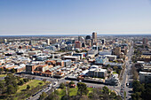
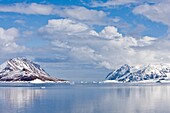
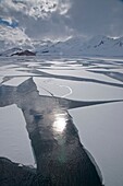
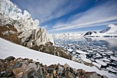
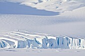
70218855 - CBD, Adelaide, South Australia, Australia - aerial
Views of Bourgeois Fjord 67°40S 67°5W is an inlet, 30 miles 48 km long in a NE-SW direction and 3 to 5 miles 8 km wide, lying between the east sides of Pourquoi Pas Island and Blaiklock Island and the west coast of Graham Land  It was discovered by the Fr
70851417 - Views of Bourgeois Fjord 67°40S 67°5W is an inlet, 30 miles 48 km long in a NE-SW direction and 3 to 5 miles 8 km wide, lying between the east sides of Pourquoi Pas Island and Blaiklock Island and the west coast of Graham Land It was discovered by the Fr
Views of Bourgeois Fjord 67°40´S 67°5´W is an inlet, 30 miles 48 km long in a NE-SW direction and 3 to 5 miles 8 km wide, lying between the east sides of Pourquoi Pas Island and Blaiklock Island and the west coast of Graham Land  It was discovered by the
70315657 - Views of Bourgeois Fjord 67°40´S 67°5´W is an inlet, 30 miles 48 km long in a NE-SW direction and 3 to 5 miles 8 km wide, lying between the east sides of Pourquoi Pas Island and Blaiklock Island and the west coast of Graham Land It was discovered by the
Views of Dogs Leg Fjord, an inlet 6 nautical miles 11 km long in an east-west direction and 1 5 nautical miles 2 8 km wide, lying directly east of Ridge Island and opening on Bourgeois Fjord, along the west coast of Graham Land  Discovered by the British
70315675 - Views of Dogs Leg Fjord, an inlet 6 nautical miles 11 km long in an east-west direction and 1 5 nautical miles 2 8 km wide, lying directly east of Ridge Island and opening on Bourgeois Fjord, along the west coast of Graham Land Discovered by the British
Views of Bourgeois Fjord 67°40´S 67°5´W is an inlet, 30 miles 48 km long in a NE-SW direction and 3 to 5 miles 8 km wide, lying between the east sides of Pourquoi Pas Island and Blaiklock Island and the west coast of Graham Land  It was discovered by the
70315658 - Views of Bourgeois Fjord 67°40´S 67°5´W is an inlet, 30 miles 48 km long in a NE-SW direction and 3 to 5 miles 8 km wide, lying between the east sides of Pourquoi Pas Island and Blaiklock Island and the west coast of Graham Land It was discovered by the